Winnats Pass walk is one that I’ve wanted to do for ages and I have no excuse for not doing it sooner.
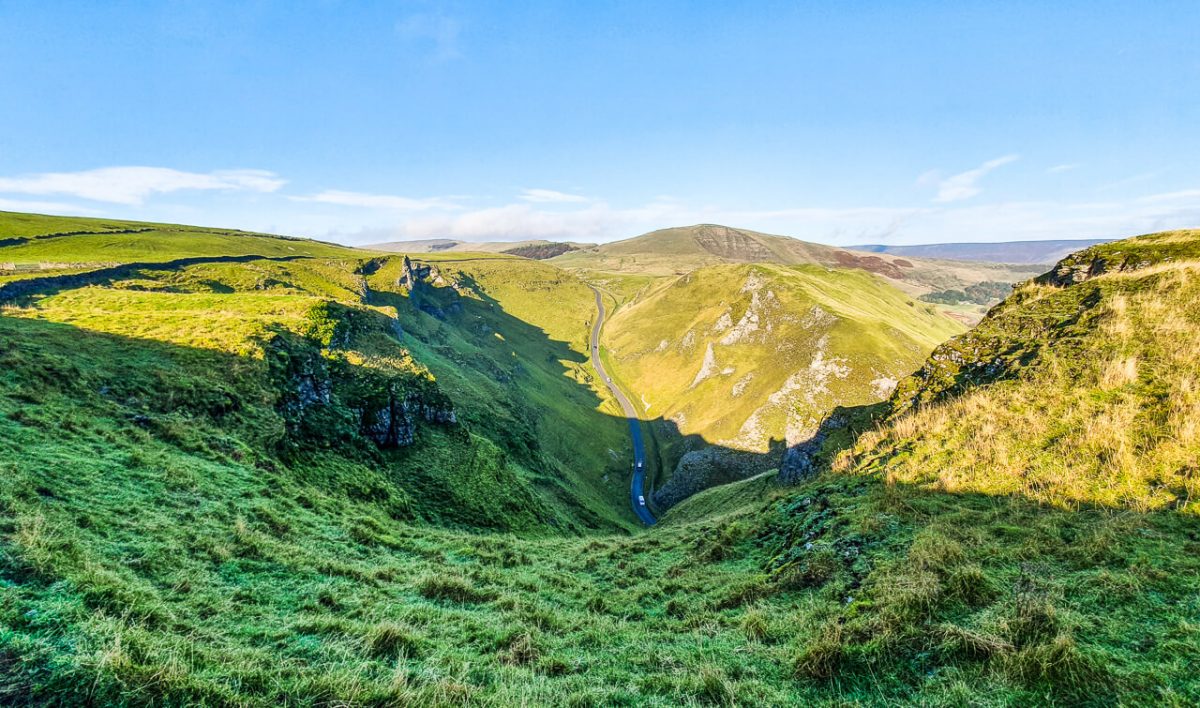
The drive through Winnats Pass to Castleton in the Peak District is stunning, I always admire the steep cliffs of the pass as I drive through.
This week on a trip to Castleton, staying at YHA Castleton I finally walked up on the top of Winnats Pass and it was epic!
Before I continue with the route description for my Winnats Pass walk I need to point out a few important pieces of information to help you decide if this walk is suitable for you.
Firstly, there are no safety barriers at the top of Winnats Pass, it’s a sheer drop in some places so please be extremely careful.
Secondly, the route I took to the top does involve a very steep part, with a short scramble section, it’s rocky and can be slippy when it’s wet. I will include easier options if you want to do a low-level walk through Winnats Pass, which is equally gorgeous!
If you have any specific questions about the Winnats Pass walk please get in touch with me beforehand, via the comments below and I will happily answer any questions.
Winnats Pass Walk (Including Mam Tor)
Here I will give you all the information you need for Winnats Pass walk, including hiking up Mam Tor afterwards.
Plus a few of my own hiking tips and things to look out for on your Peak District trip!
The route I have described takes you in a clockwise direction, which I personally found easier as the steepest section involves you going up a tricky route and it’s much easier to do this going up instead of coming down.

*Becky the Traveller participates in the Amazon Services Associates Programme, as well as other affiliate programmes. If you make a purchase through these, I earn from the qualifying links. This is at no extra cost to you. Read more here.
Winnats Pass Walk Details
Walk distance: 5 miles/ 8 km
Walk time: 2-3 hours
Total ascent: 382 m/ 1,253 ft
Walk rating: Hard (medium option available)
Map required: Ordnance Survey OL1 Peak District – The Dark Peaks
Buy your Ordnance Survey map from Amazon or Ordnance Survey here.
Winnats Pass Walk Route
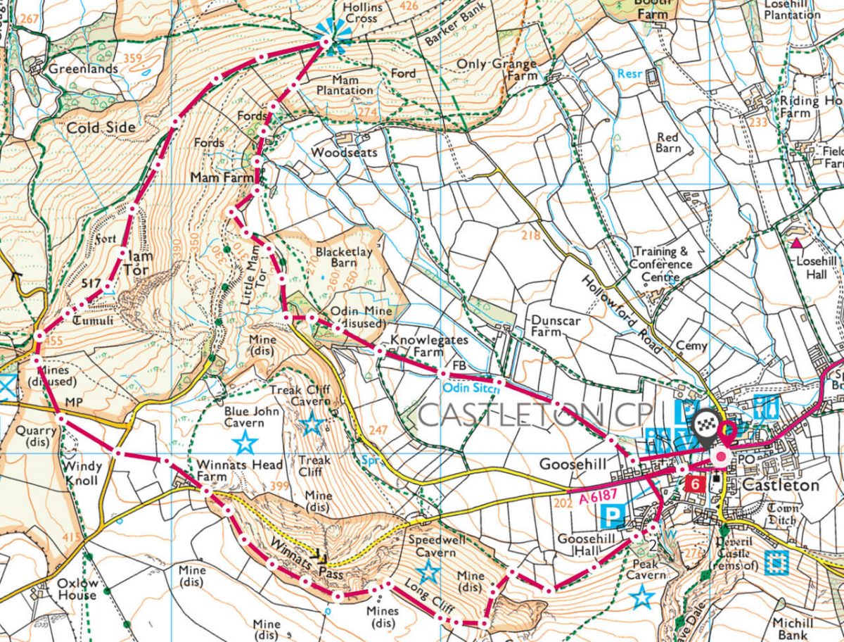
Walk Start Point
Grid reference: SK 150 830
This walk starts from the car park near Castleton Visitor Centre, where there is a shop, cafe and toilets. The car park is pay and display and is cash only.
No card payments so bring some change!

Car Park Prices
£1.20 – up to 1 hour
£2.00 – 1-2 hours
£3.40 – 2-4 hours
£5.20 – 4-10 hours
Winnats Pass Walk Instructions
I recommend that you have a map and compass with you and are comfortable using on your walk. I use a Silva 4 Expedition Compass, also recommended by Duke of Edinburgh and Mountain Leader Training.
Stage 1 (Castleton Visitor Centre to Winnats Pass)
Grid reference: SK 150 830
From Castleton Visitor Centre, turn right onto the road (A6187) and walk down the pavement for about 200 metres.
You’ll go past an old garage, then on the left-hand side of the road there’s a car park with a fingerpost sign.
Turn left here, walk through the car park and on the other side you’ll reach a cute bridge and a few houses.

Walk alongside the stream, following the sign for the Peak Cavern, you can pop down the path here to see the entrance to the cave, it only adds a few minutes to the walk and it’s pretty cool to see!
To visit the cave it is a paid attraction in the Peak District, so be sure to plan enough time if you want to visit.
If you opted to do the detour to the cave, you’ll now turn left and if you didn’t then turn right up past a narrow street of houses.
Turn left and up the road until you reach a gate that takes you to a single track path alongside a wall. At this point, you’ll be able to see the Great Ridge and Mam Tor on your right and the top of Winnats Pass in front of you.
Follow the path around until you reach a second gate. At this point, you can see a rough trail heading steeply upwards via the gully.

(Other option available – see bottom of post)
On the day I hiked the route, it was a dry day, yet some of the rocks were still slippy so take it slow. There’s also a really steep section where a rope has been tied to a gate post.
After testing the rope it felt secure so we used as an aid to hike up this section. Please double-check before you use it, in case it has moved!
Continue following the gully all the way to the top, until you reach the grassy top of Long Cliff. From here follow the boundary wall all the way around until you reach the top of Winnats Pass.
Stage 2 (Winnats Pass to Mam Tor)
Grid reference: SK 138 825
Once you reach the top of Winnats Pass, there is a trail that leads close to the boundary wall and takes you all the way across the top of the pass.
There are a few places you can walk closer to the edge of the top if you choose to do this please be careful near the edge. Sorry, don’t mean to sound like your mum haha!

The views are really beautiful from Winnats Pass top, watching the tiny cars winding through the pass making their way to either Castleton village on one side or Edale on the other.
Continue along the top of Winnats Pass, then gradually descend towards the road. Once you reach the road, cross over and go through the gate on the other side.

Head left on the footpath, heading in the direction of Mam Tor. You’ll cross over another two roads before walking up the final slope that takes you to the bottom of Mam Tor. In winter, you’ll probably find lots of children sledging down this bit!
Go through the gate at the top, where you’ll see a sign for Mam Tor and follow the flagstone path to the summit, marked with a trig point. It’s a steep but short climb and it’s a good path all the way.

Stage 3 (Mam Tor to Castleton Visitor Centre)
Grid reference: SK 127 835
After stopping to admire the views and maybe a quick photo if it’s not too windy, then continue from Mam Tor summit down the flagstone path on the Great Ridge.
On a clear day, you should be able to see the top of Lose Hill at the other end.

Follow the path for over 1 km, remember to stop and takes lots of photos! When you reach the stone marker of Hollins Cross, there are multi choices of paths from here.
Take the path on your right that almost doubles back on the route you’ve come down. Keep descending for about 500 m until you reach the old road, due to subsidence this road is no longer in use, you can see plenty of evidence of uneven ground around you.
Follow the road for a short distance, then after another 300/400 m look for a footpath that takes you back into Castleton via footpaths instead of the road. Of course, if you prefer you can continue on the road if you want!
Tah dah, you should now be back in Castleton! Why not treat yourself to some cake or maybe a pint!
Options for Winnats Pass Walk
If you don’t fancy the scramble up to the top of Winnats Pass, then instead of hiking up the gully to Winnats Pass, continue on the footpath that will lead you out to the road near Speedwell Cavern.
From here you can walk along Winnats Pass and admire the views looking upwards. There’s a boundary wall and I’d recommend walking on this side as the cars can go fast on this section (even though they shouldn’t!)
More Walks in the Peak District

Planning a longer trip to the Peak District and want some more walks to do.
Here are some of my favourite Peak District walks
- 10 walks from Edale including Kinder Scout – only the other side of Mam Tor
- Walks from Castleton – Mam Tor, Lose Hill and Win Hill walk
- Derwent Edge walk – not far and a beautiful hike with views of Derwent Reservoir
There are many more beautiful walks you can do in the Peak District, click here for all my walk in both the Dark Peak Area and White Peak Area of the Peak District.
Buy your Ordnance Survey map from Amazon or Ordnance Survey here.
- Dark Peak Area – Map OL1
- White Peak Area – Map OL24
Where to Stay in the Peak District?
There are plenty of gorgeous places you can stay in the Peak District, these are some of my favourite villages where you’ll find a mix of different accommodation to suit your trip.
Places to stay in Castleton – Holiday homes, guesthouses, bed & breakfasts (27 available)
Places to stay in Edale – Holiday homes, guesthouses, bed & breakfasts (14 available)
Places to stay in Hope – Holiday homes, guesthouses, bed & breakfasts (12 available)
Places to stay in Bamford – Holiday homes and guesthouses (9 available)
Or you could always see what’s available via Airbnb, you can stay at some really cool places. I stayed at a Yurt in Buxton via Airbnb, you can read about it here.
If you haven’t tried Airbnb yet then click here for money off your first stay.
Do you have any more questions about this walk?
Maybe you’re staying for longer or want to know if the Winnats Pass walk is right for you? Ask me any questions in the comments below
Save to your Hiking Pinterest Boards


Pingback: 12 BEST Views In The Peak District (+ Walking Routes) – Peak District Walks
Which direction do you take if you decide not to do the paid cave excursion?
Sorry, not sure what you mean, this route doesn’t include a paid cave excursion so you can just follow it as it is 🙂