Are you ready for loads of amazing hikes in England?
Over the past 10 years, I’ve done some beautiful walks and now I’m sharing my best day hikes in England.
I’ve included walks from all over England, well everywhere that I’ve hiked so far. Let me know in the comments of any great day hikes that I’ve missed out and I’ll be sure to add them to my list.
All the hikes are organised by location, you can search best day hikes in the north, midlands or south, so you can read the full list or skip to the area that is near you.
The list I’ve created is all walks that I’ve either done as a day hike or as part of a longer multi-day hike. Let me know if you have any questions in the comments below.
Here are my best day hikes in England. I hope you find some inspiration for your next walk.
Starting off with some wonderful hikes in the north of England, including the Lake District, North Pennines, Northumberland National Park and North York Moors National Park.
The north of England does have some amazing places to visit and it was hard to pick my favourites but here are my top 7.
Blencathra hike, Lake District
Views from Sharp Edge, BlencathraRoute location: Scales, nr Keswick, northern Lake District
Walk distance: 5.3 miles/8.6 km
Total ascent: 729 m/2,392 ft
Blencathra is a great day walk for all hikers, there’s a mix of different routes up to the 868-metre summit. From a more gradual route up to some fun scrambles via Sharp Edge and Hall’s Fell Ridge.
It’s by no means an easy day hike as you’re walking quite a distance vertically but the views on a good day are totally worth it.
If you opt for the Sharp Edge route (walk details below) you have two choices which route to ascend to Blencathra summit from Scales Tarn, so if you decide it’s not for you or the weather conditions aren’t great you can turn left at the tarn and ascend via a less-challenging path.
Please note in wet conditions the slate rocks via Sharp Edge are really slippy.
Sycamore Gap on Hadrian’s WallRoute location: The Sill, nr Haltwhistle, southern Northumberland National Park
Walk distance: 4.4 miles/7.1 km
Total ascent: 255 m/837 ft
This is only a very short section of the 86-mile Hadrian’s Wall but it’s one of my favourites and it’s perfect for a day walk.
From ‘The Sill’, you simply follow the road up to the path and turn right heading up onto Hadrian’s Wall. Then you simply follow the remaining wall, which is pretty intact along this section of the path.
You’ll go via Sycamore Gap, made famous from the Robin Hood film, but it’s worth it too. And then further along the path, you’ll have beautiful views of Crag Lough below.
There are two options for this walk, you can simply walk along the wall and back the same way or opt for my route which takes you back away from the wall along a quieter path but with pretty views looking up at the wall.
And to finish your walk ‘The Sill’ has a great little coffee shop, with cakes for an after walk treat!
High Force waterfall in North PenninesRoute location: Nr Middleton-in-Teesdale, North Pennine AONB
Walk distance: 4 miles/6.6 km
Total ascent: 131 m/430 ft
This is a beautiful short day walk that you can do in the North Pennines. Although, when I hiked this section I did as part of the Pennine Way National trail which I hiked in 2019.
Both Low Force and High Force are spectacular waterfalls but the walk alongside the river is equally beautiful and a perfect for wildlife spotting along the way.
GPX fileLonger walk option
If you fancy a bigger challenge, the walk I did that day was from Middleton-in-Teesdale to Dufton 20 miles/32 km (view walk map here), one of my favourite days on the trail, including many waterfalls and the wonderful High Cup Nick (see next walk route!)
This route is harder to do as a day walk as there’s no public transport linking the two places, but it would work with two cars, or walking and camping.
Views at High Cup NickRoute location: Nr Dufton, North Pennines, AONB
Walk distance: 7.7 miles/12.4 km
Total ascent: 422 m/1,384 ft
If you’ve not heard of High Cup Nick (I hadn’t before I walked the Pennine Way), you’re in for a treat.
From the lovely village of Dufton, you steadily climb into the hills. Once you get high enough if you look west you can see the beautiful peaks of the Lake District National Park, which in itself is a real treat.
The walk takes you along a path alongside High Cup Nick but it’s not until you reach the end at High Cup Plain that you get to see the most amazing views.
The photos don’t do it justice, this is one walk you definitely need to do to see with your own eyes. I’d recommend checking the weather beforehand, my first times the views were stunning and the second time all I could see was thick low hanging clouds.
Helvellyn in the Lake DistrictRoute location: Glenridding, central Lake District
Walk distance: 7.6 miles/12.2 km
Total ascent: 928 m/3,045 ft
Another brilliant but challenging day walk that you can do in England, in fact, Helvellyn was rated as the no. 1 best day walk in the UK by walkers.
From Glenridding, you head up towards Red Tarn, then up via Swirral Edge, a short scramble route up to Helvellyn summit. The views from Helvellyn on a clear day are amazing, with views across to Ullswater.
Then once you’ve enjoyed your time on the summit, had your photo by the trig point and maybe a drink in the small shelter it’s time to head down via Striding Edge.
The descent is pretty steep and tricky for this section, I remember vividly the first time I did this on the Coast to Coast walk with a heavy pack!
But take your time and enjoy the scramble down, then you’re on to Striding Edge itself. Climbing up onto the ridge is probably the hardest but, once you’re on the edge, although it’s exposed the route is straightforward. If you prefer you can drop down to the left of the ridge to a path.
This route takes you back via Birkhouse Moor hill, before descending back to the start.
Enjoying the views on Rosedale walkRoute location: Rosedale, North York Moors
Walk distance: 9.8 miles/15.8 km
Total ascent: 496 m/1,627 ft
A longer day walk, this route in the North York Moors takes you along disused railway tracks and past the old ironworks, so it’s a great walk for history lovers as you can really immerse yourself into how things used to be in the area.
If you want to shorten the walk there’s a lovely tearoom at Dale Head Farm, they do coffee and cakes, what more could you want.
Or alternatively, if you are doing the full route there’s another place you can stop, a short distance off the route – The Lion Inn. I stayed here when I walked the Coast to Coast path, they do amazing food!
Hiking up to Ullock Pike in the Lake DistrictRoute location: Dodd Wood, nr Keswick
Walk distance: 5 miles/8 km
Total ascent: 712 m/2,335 ft
From Dodd Wood, this walk takes you through the woods at the start where you have a chance of spotting red squirrels. Then it’s a steady incline all the way to Ullock Pike via the Edge.
Since you’re walking on an edge, there are lovely views both sides, down to Bassenthwaite Lake on your right and if the weather is behaving, then you should be able to see Skiddaw summit looming on your left. As you can see, the clouds were being rather mischievous when I did the hike.
If you fancy an added you climb you can add a hike up and down Skiddaw but I think this 5-mile route makes a great walk for a morning or afternoon in the Lake District.
Moving on to my favourite walks in the Midlands. This is an area that’s local to me so you’ll notice lots of walks in the beautiful Peak District, along with the south Yorkshire Dales National Park as well as some great local walks in and near Nottingham.
There are so many great places to visit in the Midlands, it sometimes gets forgotten about but hopefully, these locations will tempt you!
Malham Cove, Yorkshire Dales
Views from the top of Malham CoveRoute location: Malham, south Yorkshire Dales
Walk distance: 4.9 miles/7.9 km
Total ascent: 236 m/774 ft
From the lovely village of Malham is another one of the best day hikes in England.
I only did this hike back in 2017, whilst visiting all the National Parks in the UK but I was totally blown away by how amazing it was.
The route below is plotted in a clockwise direction and I feel this is the best way to see Malham Cove. As you walk towards this huge limestone cliff it’s an overwhelming and stunning sight.
Then you have the climb up to the top, via the left-hand-side, which leads you onto the magnificent limestone pavement, it’s one natural beauty after another with this walk. You might even recognise this from the Harry Potter films.
The view from the top of Malham Cove is beautiful, then from here, you continue walking until you reach Gordale Bridge. At this point, you can take a mini diversion to Gordale Scar, another wow moment on the walk!
Lastly, you’ll walk past a small but very pretty waterfall, Janet’s Foss, before looping back round to Malham village where you can reward yourself with either cake in a teashop or a pint in a pub. The choice is yours!
Views from the top of Thorpe CloudRoute location: Thorpe, southern Peak District
Walk distance: 10 miles/16 km
Total ascent: 574 m/1,883 ft
Now before you start thinking that Dovedale and Thorpe Cloud is a 10-mile walk, don’t worry, you can do a much shorter option too.
This 10-mile circular loop that gives you the full Dovedale experience walking alongside the River Dove to Milldale then loops back up across the fields before joining up with the Tissington Trail.
Dovedale walk and Thorpe Cloud are extremely popular during peak season, especially with families as those stepping stones attract everyone. If you fancy enjoying the walk to yourself, then go on a cooler day or midweek if you can.
Wollaton Hall and Deer ParkRoute location: Wollaton, Nottingham
Walk distance: 10 miles/16 km
Total ascent: 574 m/1,883 ft
After living in Nottingham for most of my life, I’m adding this lovely walk around Wollaton Park and Highfields Lake to your list of beautiful England walks.
Sometimes you don’t appreciate what’s on your doorstep! This route takes you around Wollaton Park, which is also home to many deer too, around the lake and Wollaton Hall, pictured above.
You can do a 3-mile loop around the park but I’ve also included an extra section walking around Highfields Lake, where you’ll see plenty of waterfowl including ducks, geese and swans. As a treat, if midway through your walk you want to rest your legs then Highfields has a boating lake too!
Fancy trying some more of my local walks? You can check them out here – Nottingham walks
Winnats Pass with views to Mam TorRoute location: Nr Castleton, Derbyshire
Walk distance: 5 miles/8 km
Total ascent: 409 m/1,342 ft
Castleton is one of my favourite locations for walks from, firstly, it’s a beautiful village with pubs, cafe and shops but for walkers, it’s the start of many wonderful walks, including Win Hill, Lose Hill, the Great Ridge and of course, Mam Tor and Winnats Pass.
Many people will drive through Winnats Pass before hiking above it, the drive through the pass is spectacular so you imagine how beautiful it is from above as well.
The Winnats Pass route isn’t for the faint-hearted, with a steep climb to the top and sheer drops, it’s not a walk for the kids! From Winnats Pass you then hike up Mam Tor, another walk that was voted in the top 10 by UK hikers.
Read more about the route here, including tips for the walk
Walking in Bradgate Park, LeicesterRoute location: Leicester
Walk distance: 3.4 miles/5.5 km
Total ascent: 146 m/479 ft
Here’s a lovely short walk to add to your list – Bradgate Country Park in Leicester.
As with most parks in England, there are many different paths to explore in the area, but this is a lovely 3-mile loop that takes you up to the highest point in the park, Old John Tower, which also means the best views!
The park is also home to lots of deer, so perfect for wildlife lovers too, as well as small wooded areas, the perfect habitat for different bird species.
Views from the top of Cheddar GorgeRoute location: Cheddar, Somerset
Walk distance: 6 miles/10 km
Total ascent: 449 m/1,473 ft
Cheddar Gorge is another one to add to your list of walks in England, it’s absolutely beautiful. From the small town of Cheddar, you gradually ascend the one side of the gorge where you get some pretty views.
The route then takes you through woodlands and on to Velvet Bottom – look carefully on the ground and you’ll see why! After you then loop back to Cheddar Gorge, with a short climb it brings you out on the opposite side where you can see for miles.
The lovely thing about this route is finishing back in Cheddar, it’s such a cute town, with icecream, cider and sweet shops, you’re spoilt for choice of what to treat yourself with!
The Roaches, Hen Cloud + Lud’s Church, Peak District
The Roaches walk in the Peak DistrictRoute location: Upper Hulme, nr Leek, Staffordshire
Walk distance: 10 miles17 km
Total ascent: 761 m/2,496 ft
Yes, another Peak District walk on this list, well, I do go hiking there a lot! This is one of my favourites as well as being in the top hikes in England too. It’s located on the Staffordshire side of the Peak District and it’s such a lovely walk.
The wonderful thing is that you get beautiful views but also woodlands and not to mention exploring Lud’s Church, which in case you’re wondering isn’t an actual church but a historic place of worship.
The walk starts climbing up Hen Cloud and immediately you have stunning views all the way across to Tittesworth Reservoir, then from there, you go on to the iconic Roaches, pictured above, with its gritstone rocks jutting out.
For more information, you can read my detailed guide on hiking The Roaches and Lud’s Church here.
Looking for even more walks to do in the Peak District, England?
As you know, I’m regularly hiking in the Peak District, I now have a second website (peakdistrictwalks.net) dedicated to all the beautiful Peak District walks I’ve done (and there are a lot).
Not sure where to start then check out the 8 best short walks in the Peak District and 12 hikes with the BEST views
Feel free to ask me any questions about walks in the comments below.
5 Best day hikes in the South of England
And last but not least, it’s the turn of the beautiful day hikes in the south of England, including Exmoor, Dartmoor, New Forest and South Downs National Parks but also the beautiful Norfolk Coast on the east of England.
I’ve explored the south of England the least, but hope to get back down there soon for some adventures!
Durdle Door, Jurassic Coast
Walking towards Durdle Door on the Jurassic CoastRoute location: West Lulworth, Dorset
Walk distance: 4 miles/6.5 km
Total ascent: 340 m/1,115 ft
Here’s a beautiful linear walk that you can extend if you want to. This 4-mile route takes you on all the highlights of the Jurassic Coast, including popular Durdle Door.
From Lulworth Cove, you hike up towards Durdle Door with amazing views of the cove behind you. At Durdle Door it’s certainly worth continuing the walk along the cliff tops. The Jurassic Coast is a 95-mile route so the path continues further if you’d like to increase your walk.
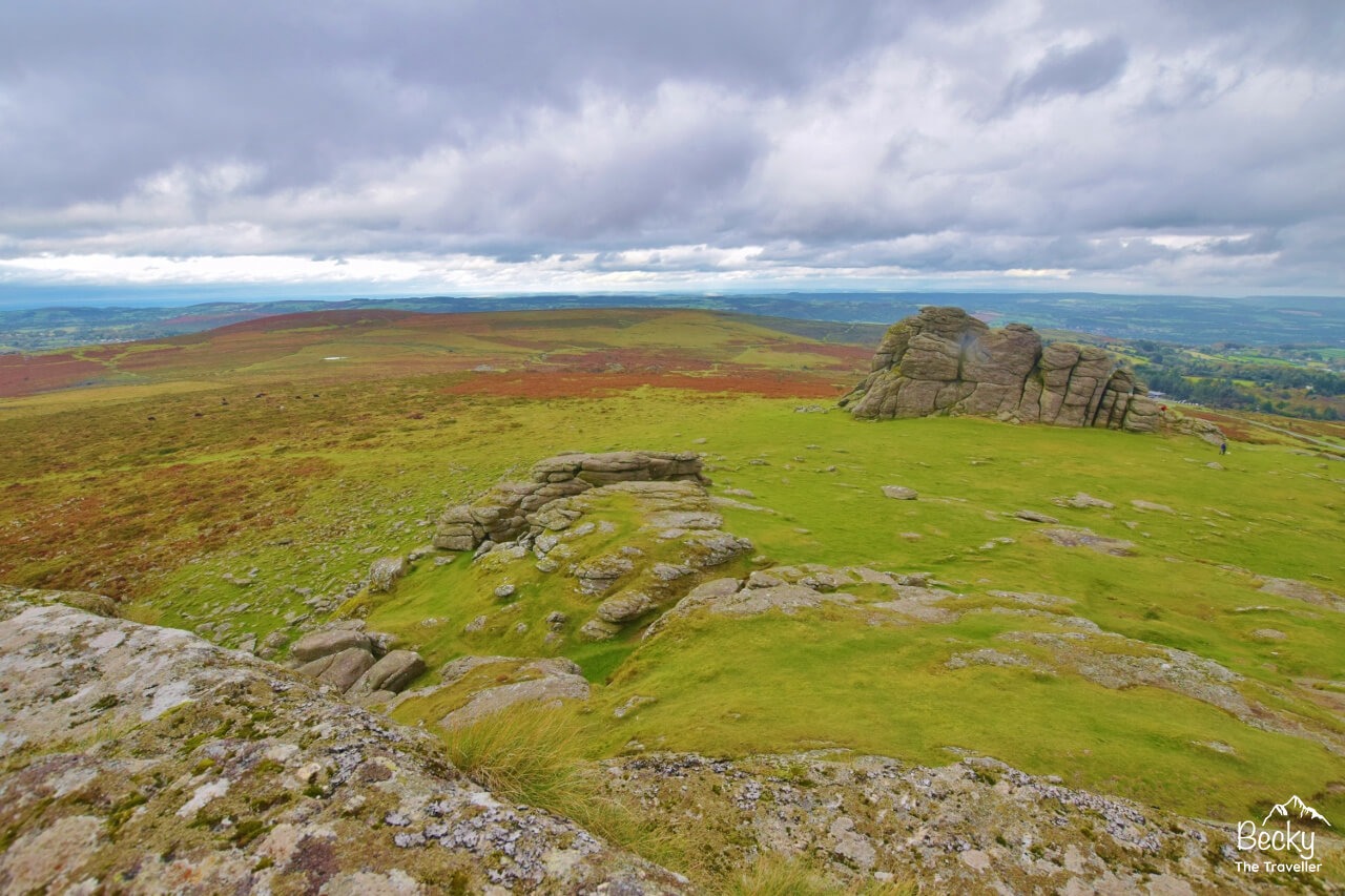
Views from Haytor in DartmoorRoute location: Haytor Vale, Devon
Walk distance: 3 miles/5 km
Total ascent: 157 m/515 ft
A lovely short walk in Dartmoor National Park, ticking off one of the 160 tors, Haytor on the loop. It also includes the nearby Haytor Quarry, a disused quarry where you’ll find rusty evidence of when the quarry was in full swing!
It’s a wonderful place to explore and see how nature has taken over the area and it now an SSSI (Site of Special Scientific Interest) so a protected area. It’s great for taking photos, with the rocks surrounding the quarry as your backdrop!
From the quarry it’s then on to Haytor Rocks, these are two large granite rocks, the highest is one at 457 metres, some way off the highest tor in Dartmoor which is 621 metres but you’ll still get some beautiful views of the National park.
Lighthouse at Beachy HeadRoute location: Nr Eastbourne
Walk distance: 5 miles/8 km
Total ascent: 289 m/948 ft
Another lovely linear coastal walk for your list, this one takes you on a beautiful section in the South Downs National Park, the newest National Park in the UK.
From Birling Gap, you are also on the seafront and simply ascend up to the cliffs to follow this lovely walk overlooking the sea below. The highlight is the viewpoint at Beachy Head where you can see the iconic lighthouse, protecting boats from the jagged rock edge of the cliffs.
Old Harry Rocks in DorsetRoute location: Studland, nr Swanage, Dorset
Walk distance: 4 miles/6 km
Total ascent: 223 m/735 ft
As a child, I visited Swanage beach but I had no idea that Old Harry Rocks was just around the corner! This is a lovely short walk from Studland, or you can also walk from Swanage but it’s a bit further to do an out and back route.
The walk from Studland takes you on a path all the way to Old Harry Rocks which are wonderful to see in person, you can walk alongside the cliff edge to get great views of them from higher up at Ballard Point, where you get to see both Swanage beach and Old Harry Rocks from virtually the same point on the walk.
Beeston BumpRoute location: Sheringham, Norfolk
Walk distance: 3 miles/5 km
Total ascent: 133 m/436 ft
The Norfolk Coast is a wonderful walk to do, the full 84-mile/135 km route can be done as a long-distance walk, starting at Hunstanton and finishing at Hopton-on-Sea. Although, when I walked the trail, I did it south the north and ended at Hunstanton, great for an ice-cream!
This is a short section, which you can complete as an out and back route, there are many different ways you can extend your walk by starting further down the coastal path or simply walking further. The path is way-marked well and you’re simply keeping the sea on your right (or left) so you can’t go too wrong!
This short route takes you to the highest point on the Norfolk Coast, at a huge height of 63 metres, but since everything else is flat you do get good views from the top!
What about Scotland and Wales? I promise, I haven’t forgotten them, in fact, I have these great walking guides for both day hikes in Scotland and also some wonderful walks in Snowdonia National Park and the Brecon Beacons too.
As the UK comes out of our lockdown, please be sure to check the different restrictions in place for England, Wales and Scotland, as there are quite a few differences.
But don’t worry, you can still plan your adventures here.
*Becky the Traveller participates in the Amazon Services Associates Programme, as well as other affiliate programmes. If you make a purchase through these, I earn from the qualifying links. This is at no extra cost to you. Read more here.
Becky the Traveller
10 thoughts on “19 BEST Day Hikes In England (+ Walking Routes)”
Emma says:
Wow there’s loads of walks on here Id like to try! We’re in North Yorkshire and Rosedale has been on my to do list for quite a while now so will have to try and get over there this summer!
Ah, that’s fab Emma, I’m glad you’ve seen lots that you’d like to try. You’re in a great location to try all the Midlands and North options quite easily! Let me know how you get on 🙂
Hi Becky,
Amazing selection of walks, have been to a few listed and have to admit they are a great pick! I will give some of the others on your list a try :). Unfortunately based in West Mids, so proves a challenge to get to places such as Lake District, let alone further north.. but will endeavour!
Ah thank you Sirrul, I’m not far away in the East Midlands, I tend to head up North for a few days at a time so then can do several day walks in one trip 🙂 Happy hiking
Hi, BTT.
Desperate to take my beloved grandson on a wild camp, but don’t know of any place we could go near(ish) to where we live (Guildford/Woking area). Do you or your fellow travellers know of any good location we can try? I’m a (now Disabled) proud British Army Veteran, so the ‘how’ (be respectful, leave no trace, etc) is sorted, but the ‘where’ is a real headache! Thanks, Becky.
Hi Shaun, ah what a lovely idea and I’m sure your grandson will love the idea, hmm, I don’t know any places myself but I’ll ask some friends and drop you an email and see what we can come up with for you 🙂
Hi Becky, im just starting out as a hiker and find your blog the easiest to read and well set out ive looked at so far. I live 10 minutes from Dartmoor so plenty of opportunity for me to explore the moors on foot rather than in my car (you must check out the secret waterfall when your next on the moor) Just to let you know you had Cheddar Gorge as a Midland walk but its most definitely South. Anyway , thanks for such a great blog, great advice and being inspiring!! Daniel
Hi Daniel, ah that’s so lovely to hear, as a beginner hiker I never found anything to help with my adventures so it’s good that you’ve come across now and hopefully it will help you explore more! Ooo the secret waterfall sounds interesting! I do need to come back down to explore again so might get in touch regarding that! And yes, haha, no idea why I was thinking Cheddar Gorge was Midlands, it just feels quite close to me and I’m based in the Midlands 🙂 Have a lovely day. Thanks Becky 🙂
Great resource this Becky. I did Bradgate park this morning along a similar route to you but took in Swithland Woods for a good 9 mile bimble. I’m looking at doing the Dovedale walk you’ve mapped out (COVID tiers permitting) this week because it’s relatively close.
Have you look at the Leicestershire round? 104 miles through the Leicestershire countryside and through some of the prettiest villages in England It also skirts Bradgate park.
Hi Mick, thanks so much (and apologises for the delay, I’ve not been well). I’m guessing you’ve already done the Dovedale walk, I hope you enjoyed it :). I’ve done a few sections of the Leics Round as part of my E2W hike, I remember lots of farmers fields but not much more sorry! Have a lovely day 🙂