
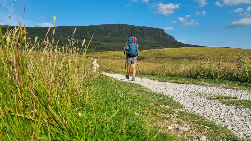
In July, I walked the Pennine Way National Trail solo, carrying all my own gear and wild camping along the way.
This was my second time hiking the Pennine Way, as I wanted to hike it again but solo this time. In 2019, I walked the trail with a friend as part of a longer 952-mile walk, my E2W Challenge.
After starting my previous trip from Edale (the official start), walking northbound (NOBO) I decided to flip the route for this attempt and go from Kirk Yetholm to Edale, southbound (SOBO).
So yes, effectively this time I was walking it backwards but it’s a great way to see the trail from a different perspective. And as I set off from Kirk Yetholm I was lucky enough to meet all the NOBO hikers on the way (all 101 of them!)
Here you can find everything from wild camping tips, food and resupply points, and water, plus loads more useful information and frequently asked questions (FAQs).
Do you fancy a challenge? Maybe the Pennine Way could be your next adventure?
Wild Camping the Pennine Way – The Plan
Here I’ll share my tips for wild camping the Pennine Way, and how I planned to split my journey up. I’ll also include where I wild camped each night, with a few other options or places that would be good camping spots.
You can also see my full kit list, which I carried in my Osprey Kyte 36-litre backpack!
I shared my journey via Instagram Stories @beckythetraveller so you can check those out via my Highlights.
About the Pennine Way
The Pennine Way trail officially starts in Edale in the Peak District and it ends in the town of Kirk Yetholm in the Scottish Borders.
The total distance of the trail is 268 miles/431 km. It’s known as the toughest national trail in the UK, due to its long remote sections of the trail. Although it’s not the longest, that’s the South West Coast Path (yes on my list – although I have hiked the 95-mile Jurassic Coast section).
The Pennine Way trail goes via several national parks and areas of outstanding national beauty (AONB) – Peak District, Yorkshire Dales, North Pennines and Northumberland National Park so there’s plenty of gorgeous scenery and views to enjoy on the way.
Check out some of the highlights below!
Highlights on the Pennine Way
This section could include so many beautiful spots that you see on the way but here are a few of my favourite highlights, from the beautiful village of Edale in Derbyshire and the lovely Nags Head pub!
I’ve added links to my Instagram photos if you want to take a look at any of the spots!

- Kinder Scout via Jacob’s Ladder
- Laddow Rocks near Black Hill
- Crossing the M62 motorway bridge!
- Stoodley Pike
- Top Withins Farmhouse
- Malham Cove
- Pen-y-Ghent
- Swaledale
- Tan Hill
- High Force waterfall
- Cauldron Spout
- High Cup Nick
- Cross Fell
- Hadrian’s Wall
- The Cheviots

How long does it take to hike the Pennine Way?
This answer is completely different for each person walking the Pennine Way trail, at 268 miles it’s certainly not a walk you can do on a weekend but with some careful planning to include 3 weekends you can potentially fit it into a 2-week block, ie. 16 days with three weekends.
However, if you’re planning to wild camp along the route this gives you a huge amount of flexibility as you’re not walking to the towns/villages with accommodation but picking your own spots to camp and sleep on the route.
Here’s the average distance you’d walk each day depending on how many days you split the walk over, this does mean you’ll have shorter/longer days.
- 20 days = 13 miles per day
- 16 days = 17 miles per day
- 13 days = 21 miles per day
- 10 days = 27 miles per day
My Pennine Way hike in 2019 took me 16.5 days, with the last day being a nice 6-mile downhill into Kirk Yetholm to arrive at the pub for lunch!
The plan for my 2021 hike was 13 days, I ended up taking 12.5 days (my half day was my first day as I started on Saturday afternoon after my train/taxi journey)

Planning my Pennine Way trip
A few people asked how I planned my Pennine Way trip and how I picked my wild camping spots.
My first task was to review the route and break it down into manageable chunks, ie. what I felt comfortable hiking each day with my full kit. I’ve done long-distance hikes before so 18-22 miles (30-36 km) each day was right for me. That’s where I came up with the 13-day plan.
I created a spreadsheet with rough sections and potential wild camp spots to see how it fitted with my plan. Out of the 12 nights I wild camped at 5 spots I’d planned, the rest were found either on the day or planned the night before (see wild camping section below).
Then I researched the main food shops on the route (see food and water section below) to work out how much food I needed to take from the start (I took 3 days of food) and for water, the first section Kirk Yetholm to Byrness had no water so I factored that in by carrying 3.5 litres from the start.
Next was looking at transport, how to get to Kirk Yetholm and when I could start hiking. I had a Plan A & B option depending on the weather. Plan A – was to start as soon as I arrived in Kirk Yetholm. Plan B was to stay overnight in Kirk Yetholm and start the following day. A few days before I checked the weather and decided Plan A would be right for this trip.

My Pennine Way route stages
I planned to split my Pennine Way hike up over 13 days, averaging about 21 miles each day. The plan was to make sure the towns and villages were in the middle of my day which meant I could stop there for food and supplies without needing to carry too much! I’ll talk about food later!
Here’s my Pennine Way wild camp route day by day.
- Kirk Yetholm to near Windy Gyle
- Windy Gyle via Byrness to Lord’s Shaw
- Lord’s Shaw via Bellingham to Haughton Common
- Haughton Common via Hadrian’s Wall and Greenhead to Slaggyford (friend’s sofa)
- Slaggyford via Alston to Cross Fell
- Cross Fell via Dufton to Sayer Hill Farm (campsite)
- Sayer Hill Farm via Middleton-in-Teesdale to Brown Rigg Moss (1 km off-route)
- Brown Rigg Moss via Keld to Great Shunner Fell
- Great Shunner Fell via Hawes and Horton-in-Ribblesdale to Pen-y-Ghent
- Pen-y-Ghent via Malham to Pinshaw Beacon
- Pinshaw Beacon via Ickonshaw/Cowing and Calder Valley to Light Hazzles Reservoir
- Light Hazzles Reservoir via Standedge to Crowden Campsite
- Crowden Campsite to Edale
SOBO route
Kirk Yetholm to Edale
- View the OS online map here
- GPX file here
Pennine Way wild camping

How easy is it to wild camp on the Pennine Way?
As a long-distance trail that goes through some remote parts of England, it’s a good one to find wild camp spots on the way. But that doesn’t mean it’s always easy!
Out of my 12 nights on the Pennine Way trail I wild camped nine nights, spent two in campsites (Sayer Hill Farm near High Force and Crowden Campsite) and one on a sofa!
For my first night, I had a rough idea of where I wanted to wild camp with a backup plan, I often plan my first night’s camp then am more flexible after that! I knew there was a Mountain Hut at the 6/7 mile point (because I stayed here in 2019) I arrived here at 5.30 pm but I was having too much fun to stop hiking.
For the rest of the hike, out of the nine wild camp spots I camped on seven hills, a high but remote spot and one low-level spot. Including the highest point on the trail Cross Fell (known for being extremely windy) and with 35 mph wind gusts it didn’t disappoint but knowing my tent would be fine at those speeds the plan worked for me.
Often when I am wild camping my priorities are different according to the weather. In rainy or strong winds I want to be in a sheltered spot but on this trip with high temperatures and low wind speeds, I opted to be higher up to avoid the midges and have a cooler night’s sleep.
My second night was the hardest one to find a spot between Byrness and Bellingham, mainly because the surrounding areas were forestry, farmland or covered in heather! I did find a small patch of grass eventually on Lord’s Shaw and did a happy dance!
Each day I’d set off then about 4/5 pm I’d start thinking about how much further my legs and I could walk, that’s basically how I picked my spots!
Wild camping guidelines on the Pennine Way
I have a detailed guide if you’re new to wild camping and you can read that here but here are the rough guidelines I used whilst wild camping on the Pennine Way.
- Always Leave No Trace – Simple and straightforward, it’s like I was never there!
- Arrive Late – I finished hiking each between 7.30-10.00 pm and I’d pitch my tent then (If I’d arrived earlier I’d have just waited to pitch my tent). But I planned my days with lots of stops to ensure I arrived late each night.
- Leave Early – Sunrise was 4.50 a.m. so my alarm went off about 4.40 a.m. to watch the sunrise then I’d be packed up and on the move for 6 a.m. The only morning I got caught taking my tent down was on Pinshaw Beacon (an early morning dog walker!)
- Pitch on Access Land NOT private land – Each of my camp spots I aimed to pitch on Access Land (shaded in light yellow on the OS maps), is not always easy in some parts and you might need to walk further than you’d planned.
- Pitch away from houses/civilisation – This was my tactic of hitting the towns and villages in the middle of the day, meaning I was then in the most remote area towards the end of the hike.

Toilets on the Pennine Way
Another one if you’re new to wild camping it might be worth reading my detailed guide on going to the toilet outdoors. Read here.
As you’ll see from my food stops below, I visited places for food, and water but also their toilets!
I carried my toilet kit (tissues, waste bag, trowel) with me, with one addition on this trip, a pee cloth, which was brilliant. Get in touch if you want to know more!

As regards public toilets, there aren’t loads on the way but there are a few! Here are the ones I found or used! Most of these are in the towns and villages so I appreciate if you’re staying here you’d probably use your accommodation but for my wild camping trip hitting these halfway through the day they were perfect.
Public toilets – Crowden, Malham Visitor Centre, Keld (paid) Hadrian’s Wall (2 sets)
Other toilets – Pit stop (between the end of Hadrian’s Wall and Bellingham)
Pennine Way Food + Water
Food on the Pennine Way
My strategy for the Pennine Way was to eat at the towns and villages en route, supporting many small independent places on my hike. It didn’t always go to plan, as some places were permanently closed and others had random days they closed (on the day I was there haha).

Here is where I ate and resupplied on the route. There looked a lot (most were lunch stops) but I probably didn’t eat as much as I should have done and some were drink/toilet stops!
- Day 1 – Kirk Yetholm – I set off with 3 days worth of food, more than enough but I wanted to give myself flexibility at the start!
- Day 2 – Byrness – No shops but I visited Forest View Inn (700 m off-route), they were closed but kindly gave me a coffee (possible honesty option coming soon)
- Day 3 – Bellingham – Breakfast at The Carriages Tearoom + resupply breakfast bars/drink at Co-op
- Day 4 – Greenhead – Lunch at Greenhead Tearoom (500 m off-route) but worth it! and Slaggyford – Resupply from Alston Co-op (my friend drove me to save the detour the next day)
- Day 5 – Alston (just before or after depending on the direction of your walk) – Breakfast butty and takeaway lunch from Nook Farm Shop (300 m off-route) and Garrigill – Bonus snack and water from the Post Office and a rest stop on the Village Green (pub currently closed)
- Day 7 – High Force – Coffee and cake with a friend at High Force Hotel (600 m off route) and Middleton-in-Teesdale – Lunch at Cafe Fresh (sorry now closed down) + resupply at Co-op
- Day 8 – Tan Hill – Drink stop at the pub (hot day!!!) and Keld – Snack stop at cafe (small menu but sausage roll and drink welcome in the heat!) Pub – no food until evening and Thwaite – Drink stop at pub (hot day!!!)
- Day 9 – Horton-in-Ribblesdale – Drink stop at pub (hot day!!!)
- Day 10 – Malham – Lunch stop at The Listers Arms (BEST food stop) and Gargrave – Resupply at Co-op
- Day 11- Calder Valley – Snack from May’s Farm Shop (400 m off-route)
- Day 12 – Crowden Campsite – snack + drinks
- Day 13 – Edale – Dinner + drinks in The Nags Head

Other places I’d potentially planned to stop at were:
- Dufton – Food fail! Plan to get lunch but the pub was closed until 5 pm and the cafe closed on Thursdays! But I had supplies!
- Hardraw + Hawes – arrived early Sunday morning pub and everything closed!
How easy is it to find water on the Pennine Way?
There is pretty much water along the whole of the route, with the exception of Kirk Yetholm to Byrness section.
At each tearoom or cafe I stopped at I asked them to fill up my water and I also drank water at pubs (lime and sodas) and cafe stops to avoid having to carry so much.
I also topped up at a campsite I’d stayed at before. A lady overheard a walker and me talking about water and offered to refill our bottles. I hiked in the crazy UK heatwave so water was in demand on my walk!

With the weather being extremely hot I also filtered and drank water when I saw it, I’d generally drink 500-750 ml at each stream then fill my water carriers to continue the route.
I’d check the water sources on my map the day before and throughout the day, many of the higher water sources had completely dried up or were still pools which I prefer to avoid. For example, Kinder Downfall was pretty much dry, God’s Bridge was stagnant pools and sources up to Fountains Fell were completely dry (just to name a few).

Pennine Way Wild Camping Kit List
Here’s the kit I took on my Pennine Way adventure! I’ve included the items I didn’t use on the trip and comments to help you decide what to take.
Please remember when you’re planning your trip that everyone’s kit list will be different, some people want to go ultra-light and are happy to relinquish some comfort for weight, while others prefer to keep their luxury items.
I’m somewhere in the middle, I’m not an ultra-light hiker but I like to go as light as I can! I’ve tweaked and replaced kit over the years but I’d rather carry extra weight and have a tent as my shelter instead of a bivvy/tarp combo.
I also don’t like being cold so I’m happy to carry an extra layer to make sure I’m warm! And yes, I took gloves, I have stupidly cold hands ALL seasons and I did use them several times.
Hopefully, you can use this kit list as a guide and amend your own kit to suit what’s important to you! You can read my spring to winter wild camping kit list including tips for reducing your weight here.
Backpack
I used my Osprey Kyte 36-litre backpack, I tested it on my 5-day hiking trip on the Cumbria Way and it fitted all my gear and food comfortably so I decided it would be perfect for the Pennine Way too!
I don’t use a pack cover but instead, I use a pack liner then these ultralight Osprey dry sacks (in different colours) to keep my gear organised and easy to find!

Camping gear
Here’s my wild camp tent/sleeping set up for the Pennine Way. If you want to go lighter then a bivvy/tarp is an option but I love my tent!
- 3-season tent – MSR Hubba NX (1.3 kg)
- Sleeping mat – Thermarest Uber-Lite – (250 g)rl
- Sleeping quilt – Thermarest Corus Quilt – (560 g)
- Silk sleeping bag liner – Silk liner – (130 g)
- Pillow – Thermarest Air Head – (145 g)
Total weight of tent and sleep system = 2.4 kg
Read my review here on my MSR Hubba NX. It’s a brilliant lightweight tent for 3-season camping trips.
Thoughts with kit
I was happy with my kit for the trip, as I camped up high I was glad I had my liner for extra warmth, but if you were planning low-level wild camps or campsites you probably wouldn’t need it.
My pillow is my luxury item, I sleep so much better with it but you could always use a down jacket/fleece as a pillow.
I had one issue with my Thermarest mat, it seemed to start deflating about halfway through the trip, I had a repair kit but couldn’t find a hole. My conclusion was it was a faulty valve, annoying but not the end of the world, I would blow it back up during the night. (I’m in touch with Thermarest now that I’ve returned).
Cooking gear
I have the MSR cooking stove kit which included the stove, cooking pot and bowl – similar to this standard one from Cotswold Outdoor. I have the Deluxe which has a self-ignitor which is very handy. I left the bowl at home for this trip.
Alternatively, check out the Pocket Rocket standard stove on its own – Base Camp Food

- Cooking stove – MSR Pocket Rocket Deluxe – 83 g
- Cooking pot – MSR one-person cooking set – 130 g
- Titanium mug – 54 g
- Titanium Spork – 21 g
- Medium-sized gas – 375 g
- Swiss army knife (11 functions – scissors, knife, bottle opener, pen + more!) – 30 g
- Lighter – 10 g
- Dishcloth
Cooking gear weight = 0.7 kg
Thoughts on my cooking kit
I didn’t do loads of cooking on the stove, mainly boiling water for a few camp meals and I love a cup of coffee in the morning and peppermint tea at night. Due to the heatwave, I had fewer hot drinks in the evening!
I could have got away with leaving my mug behind and using the cooking pot as my drinking vessel and I didn’t need to use the lighter as my ignitor worked perfectly!
Gas – I used less than half the gas canister and could have taken a smaller one but I find the medium-sized more cost-effective for me. (*Picture shows a large gas cylinder taken on a different trip!)
Clothes + footwear
Here’s the clothing and footwear I wore/took on the hike!
- Hiking shoes – Salomon XA Pro 3D V8
- Waterproof jacket – Salomon 360 lightweight jacket
- Waterproof trousers – Salomon Bonatti (didn’t use)
For my long-distance hikes, I have one set of clothes for hiking and one set for when I get to camp (thermals, socks and a down jacket).
- Base layer – t-shirt (wear)
- Thin hoodie (wear)
- Thin fleece (wear)
- Hiking shorts (wear)
- Sports bra (wear)
- Warm down jacket (for camp)
- Underwear x 4
- Socks x 4 (camp socks 2 x hiking socks)
- Buff
- Thin hat
- Gloves – Sealskinz
- Thin base layers for sleeping/camp clothes

Thoughts on clothes
Lesson one you can never predict what the British weather will do! The first week the temperatures were warm but comfortable, the second week they rocketed and made for some tough days!
I did start hiking early on most days when it was cooler so I was glad to have my thin hoodie, fleece and waterproof for hiking (I didn’t always wear everything, it depended on how high up I’d camped).
If I’d not planned to camp up high I could have got away with leaving my down jacket behind and only having the fleece but I did wear both together several times once I’d finished walking for the day (mainly week 1).
My waterproof trousers I didn’t wear, even when it rained, the forecasts weren’t awful and I’m not a fan of shorts/waterproof trousers combo. I probably could have left behind!
Other hiking gear
- Hiking poles
- Watch + cable
- 500 ml water bottle – Salomon soft flask + XA filter – 70 g
- 2-litre hydration pack + lid – Platypus – 40 g
- Water filter + 1-litre – Platypus Quickdraw – 134 g
- Toilet kit – trowel, wipes, tissues, bag for rubbish – 277 g
- First aid kit + repair kit – 189 g
- Head torch + cable – 97 g (LedLenser rechargeable torch)

Thoughts on hiking gear
At the start (or end) of the trail (Kirk Yetholm to Byrness) there are no good water sources so I carried extra water (why I took the 2-litre hydration pack). For the remainder of the trip, I carried about 1-1.5 litres of water and used the filter. (I’ll cover in detail below).
First aid kit – I used various items, I wish I’d taken anti-histamine cream (my friend met me in Hawes and gave me some). I treated a lady who’d fallen and wished I’d had some bigger graze dressings to help her.
Other items
- Small tripod with phone holder – 76 g
- Phone + cable
- Faster charging plug
- Waterproof phone case – Aquapac 43 g (didn’t use)
- Power bank x 2 (Anker 20000 359 g + Anker 10000)
- Toiletries – Toothbrush, toothpaste, hanky + lip balm
- Suncream + sunglasses
- Talcum powder + friction balm
- Bug spray (Smidge) + midge net
Thoughts on other items
I bought the 20000 Anker power bank for my 5-day Bob Graham hike and it was amazing so it came along on this trip. I also charged my phone at cafes en route and I used my phone in flight mode to preserve battery. I just about lasted the trip, with my last day only having 60% for the full day. As I was posting on Instagram I used more than a normal amount!
Due to the weather, I needed more suncream, I’d planned to buy more but my friend met me in Hawes and I topped up my small bottle from hers 🙂 And not surprisingly due to the weather I didn’t need to use the Aquapac but I would still take it again.

Food for the hike
Here’s the food I took from the start, enough for 3 days, with my first food stop at Bellingham at the start of day 3 to re-supply.
- Peppermint tea bags x 20
- Coffee sachets x 12 (Campfire coffee)
- Freeze-dried meals x 3 (Huel + Summit to Eat)
- Breakfast bars x 6
- Snack bars x 6
- Kendal mint cake x 1 small pack
- Clif energy bloks x 3 packs
- ORS hydration tablets – 1 tube (20 tablets)
- Trail mix x 1 (own mix including dried fruit, nuts, sweets)
- Bar of dark chocolate
Base Camp Food is great as you can buy a range of different freeze-fried meals, instead of buying one brand you can select different options from their range of brands, including Summit to Eat, Firepot and Expedition Foods.
Kit weight
Here is the weight of my kit at the start of the walk:
Base weight (all camping + other kit) = 8.5 kg
Food (listed above) = 1.6 kg
Water (3-litre)* = 3 kg
Total weight = 13.1 kg
*Note – I carried more water at the start due to the lack of water in the Cheviots section, however, after I found water sources and filtered water. so only carried about 1-1.5 litres.
My weight once I’d left the Cheviots was between 10-11 kg (roughly).
Pennine Way – Useful Information
Transport to the start/finish of the Pennine Way
This will largely factor on where you live in the UK (or abroad!) Out of the two locations, Edale is by far the easiest location to get to with Kirk Yetholm having limited options, that’s if you’re relying on public transport, which is the case for the majority of people doing the walk.
Edale – There is a train station about 1 km from the start of the trail. The train route is accessible from both Sheffield and Manchester, with trains roughly 1 per hour.
Kirk Yetholm – The nearest train station is Berwick-upon-Tweed, from there you need to catch two buses to the start. The no. 67 bus from Berwick-upon-Tweed to Kelso (1 hour) and then a second bus, no. 81/81A from Kelso to Kirk Yetholm (20 mins).
Trains – book in advance to save money, also look to split your journey and buy separate tickets – I use Trainline
Bus timetables
- Borders Buses no. 67. Cost = £5.30 adult single
- Peter Hogg of Jedburgh no. 81/81A. Cost = £ unknown
The factor you need to consider is the buses run limited services so there’s a large wait between the train times and bus times. An alternative is to use a local taxi service (Chris Horton recommended by the Pennine Way Facebook group).
A taxi from Berwick-upon-Tweed would be £40* or from Kelso is £16*. Call Chris to book at 07768 070818. (I used Chris’s taxi service and it was brilliant)
*Prices correct at the time of writing

Pennine Way accommodation
Airbnbs, B&Bs, guesthouses
If you’re planning on hiking the Pennine Way and staying in accommodation then my best tip is to get your trip planned and book your accommodation now!
There are some places that have plenty of options, but others are more limited so it’s worth getting the whole lot booked for peace of mind 🙂
Campsites + wild camping
If you’re planning on camping the route, whether that’s wild camping or staying campsites then you won’t need to book. You can if you want, but all the campsites on the Pennine Way have a walkers rule, ie if you’re a walker then they will find a space for you!
I stayed mostly at campsites in 2019 hike and didn’t book any of them. On this trip, I stayed at two and didn’t book them either.
Where can you get food on the Pennine Way?
Resupply stops
Whether you’re wild camping, staying in campsites or accommodation you’ll probably want to restock your food supplies on the way. There are a mix of small shops and supermarkets along the route.
General store/farm shop – Edale, Calder Valley (May’s Farm shop), Horton-in-Ribblesdale, Airton + Kirk Yetholm
Supermarket – Co-op/Spar – Hebden Bridge (off-route), Gargrave, Hawes, Middleton-in-Teesdale, Alston + Bellingham

Pubs, cafes, tearooms + honesty boxes
In each town and village, there’s normally either a shop, pub, tearoom or a mix of everything!
Also along the walk, you’ll come across honesty boxes, so make sure you pack some change to buy treats on the way!
What bothies + shelters are on the trail?
There are a few bothies, managed by the Mountain Bothy Association on the route, most of these are on the northern section of the route. At the moment, current guidelines are that the bothies are now open again but it’s worth reading their guidelines if you plan to use them.
Bothy
- Top Withins Bothy – SD 98104 35354
- Greg’s Hut (near Cross Fell) – NY 69082 35419
- Spithope Bothy (slightly off route near Bryness Hill) – NT 76674 05414
- Mountain Refuge Hut (near Lamb Hill) – NT 80405 12879
- Auchope Hut (near The Cheviot) – NT 87723 20164
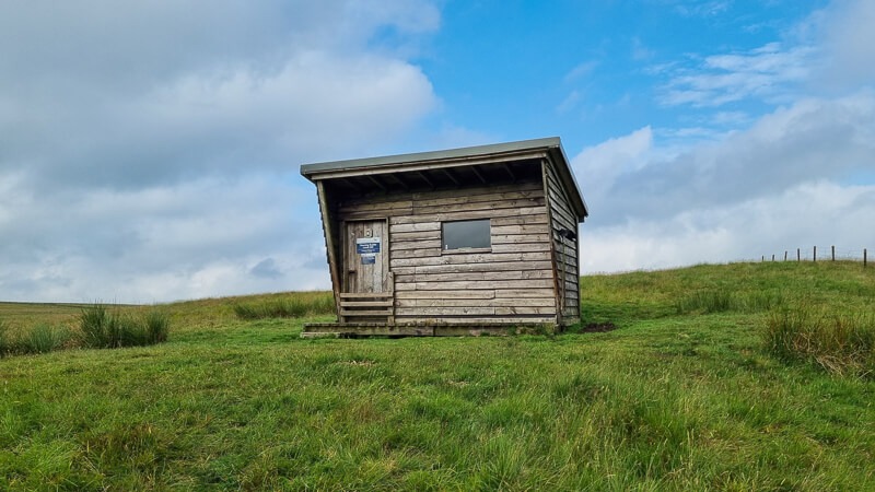

Shelter
These are more basic wind shelters, mostly without cover on top!
- Pen-y-Ghent summit
- Little Dunn Fell* – NY 70364 33196
- Cross Fell summit* – NY 68752 34335
- The Cheviot (near summit)
*(A better shelter is Greg’s Hut about 1/2 km further on)
As you can see, there is limited shelter on most of the walk, with the exception of cafes, pubs and tearooms on route!
My Pennine Way costs
I decided for this Pennine Way trip that although I was doing it on a budget as regards accommodation I wanted to spend money in the local towns and villages in their cafes/tearooms and pubs to support independent businesses on the trail where possible!
Most of my food stops were during the middle of the day so I didn’t want to eat a huge meal before continuing hiking but I still treated myself where possible!
If you wanted to do the trip on a budget, you could save money on travel by catching two buses instead of a taxi £7 versus £40 (from/to Kirk Yetholm). Or eat out at fewer places on the route, (my biggest food bill was my meal at the Nags Head in Edale £32)
Food + drinks (5 x cafes/tearooms) = £53.65
Food + drinks (2 x pubs) = £39.70
Pub stops (4 x drinks only) = £10.25
Resupply food + drinks (3 main shops + 4 smaller shops) = £64.08
Campsites (two) = £13.00
Travel (tram, train + taxi) = £52.40 (a family member works for Cross Country trains so I was lucky enough to get a discount)
Total costs = £233.08

Pennine Way FAQ
I did a short Q&A via my Instagram which you can view in my Highlights. I couldn’t answer every question so here are a few answers here to the common Pennine Way questions.
How do you cope with cows?
I met a lot of cows on the Pennine Way trail, some were not bothered with me in the slightest, others glanced up as I walked by and some were a pain and refused to move! My thoughts are, firstly, this is a National Trail, the cows on the trail are fairly used to people and are mostly due curious and want to say hi!
My techniques were either walking a slightly longer route around them, telling them to move, or when I was really tired I just headed straight through the herd!

Is there a big difference in doing both ways?
A difficult one to answer, I hiked a different journey each time, the first with a friend then this time solo. My first trip had a mix of bad weather, rainy days and missing views, whereas this trip was almost 100% views and a crazy heatwave to deal with!
The Cheviots is known as a tough section and I’d agree, that felt good to do at the beginning on fresh legs also, arriving back into a familiar place, Edale was a lovely welcome home.

Walking in the opposite direction means you get to see views from a different perspective, heading towards Horton-in-Ribblesdale from Hawes and seeing Ribblehead Viaduct and Pen-y-Ghent ahead.
I also walked up the long track to Greg’s Hut and Cross Fell, one that in the opposite direction feels tough but I quite enjoyed hiking up it!
The sections I was slightly concerned about were the downhill scramble from Cauldron Snout and Pen-y-Ghent, but in dry weather, I found them relatively straightforward. I took it slow and steady, although I did bend my pole on the way down from Pen-y-Ghent oops!
Is the Pennine Way well signposted? How much map reading skills do you need?
For this trip, I used a combination of GPX on my watch, a simple direction arrow and a line. Plus OS Maps on my phone. I also used the signposts to guide me too, a combined effort. Oh, and I had the advantage of doing the trail once in full as well as Edale to Horton-in-Ribblesdale before.
Overall, I missed my turning twice, both on tracks when I got carried away and forgot to look where I was going, but I was only 200 m off route so not too bad!
There is good signage along a good chunk of the trail but there are sections that you need to be keeping an eye on the route. For example, Greenhead to Slaggyford feels like an easy section to go wrong (I met 6 people who’d gone off-path on that way!)
Generally, the signs were better throughout the National Park sections and seemed to fade slightly on the in-between sections. You’d notice a mix of different official-looking ones to some fairly simple PW signs!

Tips for blister prevention and how to continue walking with them?
Blisters are something that affects everyone differently, I have rather awkward feet (different sizes and bunions haha) so it does mean that certain toes get more squashed than other people’s!
My tactic for foot care was…
- Take my socks and shoes off at rest stops, letting my feet breathe
- Do not ignore little niggles where possible, get them plastered and taped up
- Use Compeed – amazing plasters but I messed up a couple of times as my feet weren’t dry so they didn’t stick properly!
- Use talcum powder to absorb extra moisture.
- End of daycare – shoes and socks off asap. Wash and dry your feet, put in clean socks and don’t get wet again. I used bread bags inside my shoes so I didn’t get them wet!

More questions about the Pennine Way?
Let me know if you have any more questions about the Pennine Way hike in the comments below. And let me know if you’re planning to do the walk too!
*Becky the Traveller participates in the Amazon Services Associates Programme, as well as other affiliate programmes. If you make a purchase through these, I earn from the qualifying links. This is at no extra cost to you. Read more here.
Hello Becky,
You could add Haughtongreen bothy to tour bothy section it’s on the edge of wark forest about 400m off trail.
Kevin
Ah yes, I had that on my list to add, the ones on there were the ones I knew about before the trail so a good shout, I even took a photo to remind me haha. Thanks 🙂
Thank you, thank you, thank you!
These guides you have written are fantastic, so much important and useful information…… I’m about to do the PW on the 8th Sept 2021. It has been 30 yrs since I’ve done any hiking, have all my kit together, been training and ready to go. Am planning, like you, to wild camp as much as possible, the info about food stops, shelter sights to see is excellent. Thank you so much Becky, really appreciated.
Hi Roland, ah that’s wonderful I’m so glad you found the guide useful, the Pennine Way is a wonderful trail I hope you had a fantastic time 🙂
Hi Becky,
Wow, Great article, as a beginner and living in North West, I was thinking of walking the transpennine from West to East as practice first. Can you point me to any good guides as I can’t find much helpful on the official site?
Thanks so much Brian, I’ve just read your second message so I’d recommend checking out my second website peakdistrictwalks.net as there are loads of walks of different lengths on there from 2 to 23 miles 🙂
Sorry Becky,
I didn’t make clear. I meant hikes across peak district, not full route. Stuff I can do in at weekends.
Hi Becky, great blog and great achievement.
I did the PW S to N in July 2020 with my cousin, and had horrid weather but still completed it in 14 days. I’m planning to go from N to S on my own next year, but each time I start to think about the weight of my rucksack it puts a dreaded fear into me. Maybe I just need to take less stuff.
Well done again.
Hi Dave, ah thank you so much, that’s really kind of you. Big congrats on completing it too! I’m intrigued how heavy your backpack was, sounds like you carried a lot! On my wild camping kit list post there are a few tips for going more lightweight, maybe worth a read to see if there are any ways you can reduce your weight 🙂
Hi Becky,
This is one of the best and most useful blogs I have come across. There is more relevant information here than in most guide books. I did the Pennine Way 40 years ago and was contemplating a nostalgic revisit (probably solo) but this time with as much wild camping as possible. Great to get some suggestions of potential sites and restocking/eating places. It brought back some fond memories.
Thanks also for your emphasis on LNT. It’s needed more than ever with the numbers of people out there.
Best wishes.
Ah thanks so much Jules, what a lovely message, how cool that you did it 40 years ago, I can imagine it being very different especially without all the flagstones! Ooo, you should definitely do it!!! I’m really passionate about wild camping but doing it in the right way so I’m glad that came across! Have fun on your adventure 🙂
Hi Becky, would you suggest it possible to walk with dogs the whole way? They are used to camping and pretty resilient and great at just being (!) but your thoughts around getting water and food would be much appreciated. Thanks Betty
Hi Betty, I guess food and water would be the same as if you were doing the hike yourself, there are some long sections where it’s limited in places so you’d need to carry enough for you both. I use a water filter however, that’s sometimes still not enough in hot weather, I know dogs drink from various water sources though so I’m sure they’d find some! I have seen several people hike with dogs, I know one thing that was mentioned was during dog weather there’s not much shelter so tough for dogs overheating, not sure when you were planning on doing though :). Hope that helps and enjoy when you do it 🙂
Pingback: Edale to Crowden Long Walk (via the Pennine Way) | 17-Mile Route - Peak District Walks
Hi Becky
I’ve just come across this blog and think it’s absolutely brilliant. I’m planning on walking and wild camping the Pennine Way with my GSD in June and so this has been really useful. I’m solving the re-supply issue for my dog by posting his food on to stages along the route for collection!
I had one question concerning the route map you did. I’ve downloaded the GPX onto my OS maps app, but I was wondering if you had one with the start at Edale and the finish at Kirk Yekholm? I can’t see any way on OS Maps of editing it so it runs south to north. Any help or suggestions gratefully received.
Hi Fred, ah brilliant, I’m glad you found it useful, good idea for the dog food that makes sense! I’m actually just back from a winter PW trip from Edale to Kirk Yetholm so if you keep an eye out you’ll see my new post which will have the GPX in it 🙂
Greetings Becky,
Excellent summary and information. I’m hoping to walk the PW in July, SOBO, so this is just what I needed to give me a few details (coming from Ottawa). I shall take a bit longer – thinking 15-17 days but still need to map it out. But going light and wild camping is the idea.
Two Q if you could be so kind (at your leisure). What are the ‘bothys’ for? How hard is it to get out of Edale to Manchester? How long might it take to get there via public transport?
Again, great blog. I enjoyed reading it and shall surely be consulting it regularly in the weeks ahead.
Cheers
James
Hi James, ah lovely to hear from you, all the way from Ottawa :). I’ve now done the Pennine Way 3 times and my first hike was 16.5 days and this winter I did it in 14.5 days so your plan for 15-17 works perfectly. The advantage of wild camping is you can hike longer or shorter days to suit you, the summer months are great as there is longer daylight hours. To answer your questions 🙂 Bothy’s are Mountain shelters, the initial purpose is for use in an emergency situation but many people stop for lunch on bad weather days to simple shelter out of the weather. I should add a note that Greg’s Hut which is below Cross Fell will be closed throughout most of June and July for urgent maintenance work as it needs a new roof (just in case you’d planned to stay there). Also, Edale to Manchester is really easy, there’s a train station in Edale, trains go approximately once an hour, there’s a link in the bottom of the post which you can search times to suit you, it takes about 45 minutes and you can either buy tickets on the day from the train station or buy in advance. Enjoy your planning for the trip and feel free to pop me any more questions nearer the time 🙂
Hi Becky. Just read your blog. Great. Thinking of doing Edale to Horton in July next year. Thinking of free camping. From what you said, it is possible, but you said you camp late and pack up early. Is that because you’re not really supposed to be camping where you did and don’t want to be found? Would it be a problem to camp earlier and/or pack up later?
Hi David, ah that’s fantastic, I did that section in 2020 with a friend, it’s a fab part of the walk to do. Wild camping is only tolerated in England and Wales when people do it in the right way, therefore I’d always recommend to camp late and pack up early to set a good example. I could probably share lots of thoughts on this as I have seen many people setting up camp early or leaving late, particularly when I’ve been on hikes during the day and still seen tents up, treating it more like a campsite. Wild camping is one of those topics that many people do and will have different thoughts on, these are my personal opinions and I’d try and encourage others to do the same so that wild camping doesn’t get a bad name (which you might have read articles where it’s already seen in a bad light). I’ve on the odd occasion set up camp earlier, maybe in awful weather, if I’m unwell or in a particularly remote area, I’d say much of your decision making will be down to you at the time. I appreciate that’s not a definitive yes/no answer but I hope that helps with your planning/decision making. Have a fantastic time 🙂 PS, you may have read it but I have a more detailed Wild Camping for Beginner’s guide on my website that might be useful 🙂
Thanks Becky. Very helpful. I found some other sites that talk a bit about wild camping too, and I think I have a feel now for what’s acceptable. I live in Australia and wild camping is quite a different matter here.
Ah you’re very welcome, I felt like I was waffling a bit but glad you picked up some helpful tips. Feel free to get in touch nearer the time if you have any other questions about your trip 🙂
Hi Becky. This is a great blog, really helpful. I’ve got a footwear question – I’m planning on a brisk south-to-north walk in early Sep this year, and wondering if I can get away with ultra trail running shoes, or need something waterproof? I think your kit list shows non-waterproof shoes, but without trying the route it is hard to know how much bog there can be. Wild camping too. Thanks
Hi James, thanks so much, glad you’ve found helpful. If I was doing in early Sept I would possibly wear my Goretex trail shoes instead of non-goretex, my preference in the summer months is so go non-goretex as even though they get wet they also dry quickly too. The route does have a fair bit of bog so it’s a choice for you whether you’re happy to get wet feet in early Sept. I’d say there are places where you can avoid the bog but then there are other places where the bog is the only choice! Sorry, that’s a totally vague answer but if you have any other questions then give me a shout. Awesome that you’re wild camping too, it’s a fab trail, I absolutely love it 🙂
A fantastic piece on the PW. I have failed to finish on 3 occasions, each time with a friend S – N. But I have completed it twice solo ( must be something in that ) again S-N. The last time was in ’83 and each time we crossed the Kinder Plateau, a quagmire of peat groughs. It does look a bit easier using the Jacobs Ladder route and there were NO flagstones way back in the 70’s. I have really enjoyed all the info on equipment etc. You can imagine how ‘normal’ our clothes were back then and how heavy our canvas rucsacs were, but I loved the experience, and would love to do it one last time. Now 77 so it would probably mean b& b’s which are not cheap these days. Thanks again Becky, good luck on future walks, try Nepal, have done 9 lovely treks out there. Bye.
Ah that’s lovely to hear Andrew, it’s amazing how to trail has evolved over the years. The initial route up Grindsbrook is still one of my favourites but heading up Jacob’s Ladder does make for a slightly easier start! B&Bs sound like a great plan, I know there are plenty of lovely ones on the route. I’ve done the Annapurna Trek but would love to return to explore more 🙂 I hope you enjoy your S-N adventure soon 🙂
Hello again Becky. James from Ottawa, 🇨🇦 here taking you up on your offer to “feel free to pop” you a few more questions. It is getting nearer as I am hoping to be on the Pennine Way SOBO around May 24. At that time of year are you aware of any particular weather-related challenges?
I was mapping out my hike using your “Route Stages”. It does look like you have some pretty big days in there, particularly near the end. Can I ask, with a pack and with some breaks thrown in, how long would you be going on any given day that saw you cover 30 km? I imagine it can be pretty slow going in spots. On wild camping, I understand it is ‘not allowed’ yet I see that many people, yourself included, wild camp. Have you ever encountered problems once you are set? Are many hikers out past dusk?
I’m in Wales before heading up to Newcastle (picking up the Pennine Way after 3 days on Hadrian’s Wall). Now I shall have a look at your hikes there for ideas and inspiration. Cheers.
Hi James, ah fantastic, lovely to hear you’re visiting in May to hike the Pennine Way. I often do a lot of hiking in May and it’s generally a good month so no big weather issues, other than the obvious UK weather that can go from sunshine to rain in an instance! I generally stop for plenty of breaks, snacks, photos and enjoying the views, I even had a quick dip in a pool on my last day so I was out for longer but with the daylight hours and camping I prefer to hike for longer days but at a more relaxed pace. Approximately I was hiking between 9-12 hours each day. No I’ve never encountered any issues wild camping, I adhere to the wild camping guidelines and as a solo female I often pick more hidden spots. Ooo fab, Wales is gorgeous, loads of great hikes there too 🙂
Hello again Becky. James from Ottawa 🇨🇦 again taking you up on your offer to “pop” in to ask a few more questions. Planning is well underway for a SOBO of the Pennine Way in late May into June, so the excitement is building.
Just wanted to ask a couple of things. First, are there plenty of places to wild camp on the trail, in case I do not make to a planned evening stop? It seems there is lots of ‘wilderness’ but how wild is it? For example, heading to Pen-y-Ghent looks pretty uninhabited so are there choices for wild camping? Second, from your description, those last 3-5 days into Edale must have been pretty long, 30+ km. Is that right? I feel I can walk a long way, have a long day but how did you manage on those consecutive long days?
I continue to scour your blog and find it both helpful and inspiring. I’m also going to do some hiking in Wales so I’ve been checking out your walks there. So thank you for documenting and sharing. Keep enjoying your walking.
James
Ah that’s lovely James, glad to hear you’re getting excited about the trip :). I’d say some parts of the Pennine Way there are plenty of spots but others where there is all private land is harder and you need to hike further to reach the Access Land. Are you familiar with UK OS Maps? Pen-y-Ghent is one of the biggest hills in Yorkshire which makes up the Yorkshire Three Peaks hike so it’s very rare that you’ll find it quiet up there.
As regards to my final three days I felt good so just kept going! You tend to build your fitness and stamina throughout the hike, I couldn’t have done those long days at the beginning but by the end I felt fine 🙂
Thanks James, hope you have a brilliant trip and let me know if you have any other questions. If you need a quicker reply then pop me a DM on Instagram @beckythetraveller 🙂
Becky,
Just read your article and it’s interesting and helpful information.
My first attempt on PW was summer 1976. I started with 3 uni mates the day after my last night at Uni . Not good as started still hung over and being 4 lads the pace was too fast/ ambitious especially given the heatwave that year. So two of us dropped out at Eat Martin on the A59 … the first Theakstons pub! The other two had a short walk to Gargrave and took a rest day. They then walked from dawn until 10 am found shade until 4 pm then walked again until dusk.
I tackled and completed it in July 1977. That time with my then girlfriend at a much more sensible pace camping sometimes wild and using some YHA hostels (Keld, Langdon Beck, Dutton, Alston, and Twice Brewed). We managed it in 16 days.
I would like to do it solo as a retirement reward to myself if my wife agrees to my absence (not keen at moment!). I hope to retire just before my 70th next July so probable in June 2024.
When I did it in 1977 I started with a pack weighing just over 15 kg. And our longest walk was from Chew Green to Kirk Yetholm so about 25 miles.
I couldn’t manage either now, so have been investigating ultralight kit so your article is extremely helpful. I am still working on thoughts but am aiming to carry no more than 7 maybe 8 kg. If I can get that low I am sure I can cover up to 15 miles most days.
I do have advantage of knowing many sections very well partly from my potholing days in Yorkshire dales and many walking trips as well as living on Hadrian’s Wall just 2 miles from Greenhead. Indeed, the PW crosses my golf club, Haltwhistle Golf Club at Greenhead!
So thank you for your tips!
David
Thank you for this site which I am finding useful as I plan my Pennine Way walk – version two. I did version one 46 years ago with three school friends and LOVED the experience. Now, aged 62 and with a little more money I hope to do almost no camping/youth hostels and generally to stay in B&Bs and pub hotels. I want to go alone for 3 weeks of rare solitude, but my wife is concerned that this is dangerous. Do you thing it is reckless for a healthy, naturally cautious 62 year old to walk this alone? I plan to take my time (at least 20 days plus break days) and of course I promise not to blame you in any way for any mishap which might occur. I’d really value your opinion, but of course I recognise that the final decision is all mine. Thank you, Francis
Sorry, my email should at the very least have started with ‘Hi Becky’.
Hi, sorry, I can’t see an email from you?
Hi Becky,
Thank you for this site which I am finding useful as I plan my Pennine Way walk – version two. I did version one 46 years ago with three school friends and LOVED the experience. Now, aged 62 and with a little more money I hope to do almost no camping/youth hostels and generally to stay in B&Bs and pub hotels. I want to go alone for 3 weeks of rare solitude, but my wife is concerned that this is dangerous. Do you thing it is reckless for a healthy, naturally cautious 62 year old to walk this alone? I plan to take my time (at least 20 days plus break days) and of course I promise not to blame you in any way for any mishap which might occur. I’d really value your opinion, but of course I recognise that the final decision is all mine.
Thank you, Francis.
Hi Francis, ah I’ve just found this in my spam folder, apologies for the delay! I’ve hiked it solo both in summer and in winter and I think if you take the proper precautions and understand the risks then hiking solo is completely fine. If you have a plan with your wife to check in each day and for her to know your route then hopefully that would put her mind at rest. There are obvious risks hiking alone, but with careful planning and carrying the right kit you can minimise these. I know plenty of people hike solo so you may end up hiking or bumping into fellow hikers on the route. Please feel free to let me know if you have any other questions. Kind regards, Becky
Hi Becky
You said you used less than half of your gas cylinder, and under the cooking section you wrote that you had a medium sized gas cannister of 361g but the photo above that clearly shows a large 598g cannister with pocket rocket attached, that indicates more gas used.?????? sorry for being picky but the photo made me question that.
Hi Frankie, yes, the photo shows a large canister, for some reason I’d not taken any pics of my stove on this trip so this photo was taken on my 950-mile hike where I carried a large canister. I’ve double checked and I definitely took a medium one for this trip :).