
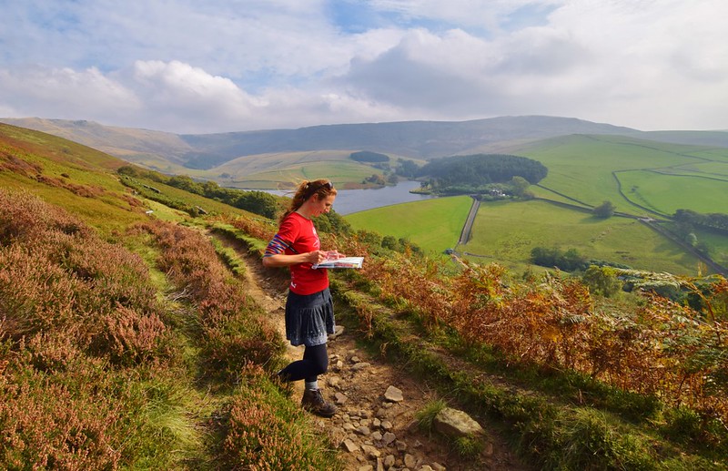
I’ve been hiking a while and I admit I am still nervous when it comes to navigation. I’m not a total beginner at map reading.
I can use a map and compass and have navigated some tricky routes in the mountains in bad and good weather, as well as in the dark with a torch.
But I wouldn’t call myself an expert.
Many people are now switching from paper maps to smartphone navigation tools. Of course, you see it all the time when visiting cities, people following the arrow on Google maps as if their life depends on it.
You can’t possibly walk the wrong way even for one second because your eyes are glued to the screen. Thus missing every tiny detail on the route.

Personally, when I travel to cities, like my recent trip to York, one of my favourite things to do is explore without a map, I try to find my own bearings, spot landmarks or shops near my accommodation so I can find my way back at the end of the day!
But as a back up I have good old Google Maps to save me from walking totally the wrong way!
So how is using a phone to navigate any different in the UK if you’re hiking outdoors in the hills or mountains?
It seems like a perfectly good idea, at first. But I’m going to share my wisdom (haha don’t laugh), experience and general thoughts on using a smartphone for navigation.
But first, what Online Navigation tool do I use?
How Not To Get Lost In The Mountains?

*Becky the Traveller participates in the Amazon Services Associates Programme, as well as other affiliate programmes. If you make a purchase through these, I earn from the qualifying links. This is at no extra cost to you. Read more here.
I have the Ordnance Survey Online Map App
Firstly, I pay for OS App, I’m now on my second renewal even though when I first had the App I didn’t really use it to its full potential. But this is one of the reasons I’m writing about it now, share the love!
There are a few options for this App.
- You can try it for a month, or if you are only visiting the UK for a holiday this would be the best option.
- Or you can sign up annually (the auto-renewal option is the cheapest)
How Much Does It Cost?
For one month the App costs £3.99
The annual cost is £25.99 or if you want to save even more then it’s £23.99 for the auto-renewal option.
If you prefer, you can sign up to the FREE basic option, to begin with, to decide whether it’s right for you.
Check out all the options here.
What Do I Love About the OS Online App?

Now, I’ve not been paid to say this (I wish) but I seriously love this App. We now spend so much time together it’s like a real relationship. But enough of the romance hehe!
The Online App isn’t just useful when I’m out hiking, it starts much earlier than that when I’m sat at home on the sofa trying to decide where to go next. I love the overall vision of a giant OS paper map on my lounge floor to get an idea of where I want to hike.
But the exact route and planning come from the OS Online.

Read next: 4 Days Hiking in the Lake District from Borrowdale
In the paid for version, I can plot my route (or routes) from the comfort of my own home and with a decent Wi-Fi, I can create various options ready for my adventures!
The ‘snap’ option on your laptop for National Parks, actually plots the exact footpaths, including correct distances and more importantly the ascent and descent of your walk so hopefully no nasty surprises on that 5-mile hike.
Read my full post here on hikes from Castleton in the Peak District.
Using The OS Online App Whilst Out Hiking

Firstly, you can use in Flight Mode… what! Yes, really, the App works in Flight Mode so helps prevents the dreaded battery drain!
When I first downloaded the App I went through that phase as we all do with a new toy or gadget of wanting to use it every 2 seconds.
Yes, that’s great but again by staring at a little dot every 2 minutes, you’re missing the point of going for a walk.
Plus there’s a big chance you will drain your battery super fast!
I now use much more sparingly and am starting to trust my map reading skills a lot more. When learning to read maps it’s a good confidence boost to predict where you are on the map and then double check with the App. Yes, you can do this without technology

You Decide!
Let’s start with a few issues, problems, complete disaster situations that you might encounter:
Limited or No Phone Signal
Firstly, have you ever tried to get a signal when you’re in the middle of no-where.
Oh, no disaster, you can’t update your Insta Stories, you can’t announce to the world via Facebook your cool check-in location and Snapchat is impossible. Oh and more importantly, you have no way to go online to see where you are!
Maybe in a valley, which has zero signal for miles, on my recent stay at YHA Borrowdale in the Lake District, there was no phone signal at all. Or maybe in another remote part of the mountains where that beautiful hill is blocking the entire phone mast.

Battery Running Out
The dreaded flashing red light. The battery is down to 10%, how did that even happen? You looked 10 minutes ago and it was at 40%. Who stole the battery? Oh, that’s right, it was that App you left open that totally drained your battery. Arhhh so annoying.
Now do you risk taking those last few gorgeous photos or do you save your phone battery for an emergency situation?
You’ll notice this happening even more during the colder winter months as batteries also do not like the cold.
Losing Your Smartphone
According to ‘Becky’s Stats’, it is possible to lose your phone. Ok, I’ve been lucky enough not to have lost mine (touch wood) but of course, it is possible.
I was convinced I’d lost mine when walking in Exmoor National Park, I blame the ponies and trying to find it felt impossible even though I roughly knew where I’d had it last.
Oh, it turned up in my secret compartment in my bag haha!

Technology Fail
Nothing lasts forever, especially when we’re talking about technology. I’m sure they make it so it’s designed to break after a year so you have to buy a new one!
Your phone and you can fight against all the elements but sometimes that heavy rainstorm is enough that your phone refuses to work or charge, hmm the good old moisture detected message is very annoying!
But Of Course, There Are Some Positives Too

No map disagreements
No arguments about where you are on the map with friends or family.
Simply take out your phone and prove you are right hehe.
Emergency Situations
In a serious emergency situation, the App will give your exact co-ordinates so you can provide them to the Emergency Services aka Mountain Rescue.
Building confidence with your map reading
As a beginner, it’s a good way to build confidence in the mountains and check you are where you think you are on the map. I will often get mine out to make sure I’m where I think I am on the map and 90% of the time I am.

Guidance in bad weather
If you are genuinely struggling in bad weather conditions, it’s an additional aid* to get you back down safely and without getting lost.
*Note additional aid, as mentioned above you still need to take a map and compass with you.
Zooming in and out
My eyesight is pretty good much, but every now and then I do like the option to zoom in to look at a bit more detail.
Or alternatively, I like to zoom out to see where I am or what that big mountain is called in front of me, which as you know isn’t always that easy in windy weather with a paper blowing everywhere!
Top Tips For Taking Your Smartphone On A Hike
A few tips if you do want to take (and use) your phone whilst out hiking or in the mountains.
1. Close down all the Apps you aren’t using. Don’t let the open Apps steal your battery power
2. Turn your phone into Flight Mode – This stops the battery from draining as your phone isn’t constantly searching for a signal. It gives your phone a lovely break too.
3. If you are using an online navigation tool as your map. Take some print screens of your planned route. Then if the App does fail you still have an image of the route
4. Take a power bank with you as a backup. Ideally, this should stay in your bag for the entire trip but in an emergency situation, you might be glad you have with you.
5. On winter hikes, keep your phone warm, ie close to your body to avoid the battery draining.
6. And lastly, always, always…
Take a MAP AND COMPASS too!

Would I Go Hiking Without My Smartphone?
If I’m totally honest, I wouldn’t.
Why?
Because in a serious emergency situation, either myself or a fellow hiker. I would want to be able to contact help ASAP.
But I do use it less when I’m hiking. You know I share my Insta Story photos from a hike but I TRY not to take too many photos and give you a flavour of the walk.
The idea is that you are tempted enough to do the walk yourself, not that you see all my photos and decide that’s as much as you need to see!
In summary, smartphones are awesome, they have amazing Apps, gadgets and technology. But nothing beats getting outside and doing some good old-fashioned map reading.
Read next: 15 best walks in the Lake District
What do you think about Smartphones?
Do you use maps and compass on their own or have you tried any online Apps for navigation? Tell me in the comments below.
Save to your Hiking Pinterest Boards


Oooh I didn’t realise that OS maps had online versions. I do really miss those maps, it would be awesome if there was something similarly detailed in Canada. I have been using mapsme, which is a free app, but you can download areas to view offline (in airplane mode) and it is reeeeally good for backcountry trails here. I still like to plan with real maps though.
One problem is lots of people use *just* online maps to find trails, and the trails are not always labeled as “hiking,””scrambling”, or “climbing” routes. There have been quite a few tourists getting themselves in trouble this summer near Vancouver by following climbing routes on their phone, without realising they need equipment to tackle those routes!
Search and rescue also keep telling people to bring spare power blocks just in case, so we bought one, but we didn’t use it much yet…
Ah yes, they do indeed and they are really handy for both planning and navigating. I do like getting a big map out to plan too but sometimes if I’m going somewhere I don’t have a map for it’s handy to start the planning process beforehand!
The power bank is a really handy thing, it just gives you some more confidence that you have a backup 🙂
Good stuff, Becky!
Some great common-sense mountaineering tips:
– Study the map before you go. Maps get wet. Batteries die. Your most powerful & reliable navigation aid is inside your skull. Use it.
– Remember to turn around – often – and look at the route back, even if you’re intending another way down/out, so that it doesn’t look unfamiliar later.
– Try to imagine where the Sun & shadows will be later in the day.
– Make note of landmarks (odd boulders, stumps, etc.) at ground level that can be seen in heavy fog or after dark.
– When in doubt, STOP. Don’t panic! A bad action is almost always much worse than no action.
– In bad conditions, only move if you’re confident that it’s the right thing to do, that you’re not going to walk off a cliff!
Have fun & stay safe!
Thanks, Scott, some really handy tips. Love the one about turning around, I try and do that to take photos which are also handy if you get lost as you can look back at them 🙂 Happy hiking too
Hi,
Trying to work out why you are so concerned about the “phone” signal. De ent GPS apps use GPS satélites fir fixing the position. You’d need to be in a pretty deep sharp valley or in a dense forest with no sky view to have no go’s signal for more than a few minutes. I never lost go’s once on the Pennine Way. I don’t just go into airplane mode, I bought a rally cheap.lsrge smartphone and gave the current app on it, apart from the things you cannot gett rid if,that’s all there us on that phone,no sin, but I fi have a memory card for all the downloaded maps. So in effect I have a dedicated GPS device. I also back up all the same stuff on my use able phone and carry a battery bank. Plus paer naps and compass.
Currently I use Viewranger with an Annual OS subscription but since the takeover by Outdoor Active and their useless software am looking for a stable and easy to use alternative. So thanks for your views on the OS app. But does it also work I Europe???????
Hi Jim, OS maps is a UK mapping system so no it doesn’t work outside the UK I’m afraid. I write mostly about the UK and share UK adventures it suits me but sounds like you might need another option if you are looking to Europe mapping too. If I test any apps I’ll be sure to update this post. Happy hiking 🙂
I use the excellent WorkOutDoors app on my Apple Watch (not available on android). £4.99 one off fee so no subscription. The vector map is very detailed and you can upload a walk to navigate and it tells you if you stray off route. Uses gps signal so no need to use mobile data. I find it an excellent app for hiking and the best for apple users.
Yes, I have a similar feature on my Suunto watch, however, I find that you need to use in additional with a map/compass as some places where there are no paths it’s not clear. Another great addition to the navigation kit though 🙂