
The Lake District National Park has to be one of the best places to visit in the UK for hiking.
I’ve done amazing hikes there over the last few years. One of my favourites is the Coast to Coast long-distance hike which starts (or ends) in the Lake District and gives you a full-on Lakes experience as you hike the trail through hills, mountains and lakes.
But if you’re not into multi-day hikes then there are plenty of great day hikes too.
Here’s a selection of my best walks in the Lake District, which includes a mix of short and long hikes hopefully, you’ll find something to suit you. But feel free to ask me any questions in the comments below.
There are also variations to adapt some of the walks for easier routes.
Or, for those of you that love a long hike, there are options to extend the walks too. You could even pack up your wild camping kit and spend a full weekend hiking.

*Becky the Traveller participates in the Amazon Services Associates Programme, as well as other affiliate programmes. If you make a purchase through these, I earn from the qualifying links. This is at no extra cost to you. Read more here.
Lake District Routes
The walks are arranged by where they are on the Ordnance Survey maps. It seemed like a good way to do it.
Simply scroll through the walks or use the table of contents to select by area.
Walk Planning?
To plan my walks, I use paper maps to initially as I love seeing the bigger picture. Then I will plot the route via OS Online to give me an exact route, distance and ascent!
On my walks, I use a mix of OS paper maps and OS Online via my SmartPhone for navigation. And a bit of winging it, but yes, I have been known to go the wrong way!
Read my thoughts on using a SmartPhone for navigation here.
Lake District OS Maps
These are the four Ordnance Survey maps that cover all the Lake District walks in this post
Buy them for your trip now 🙂
Or buy the full set of four maps and save some pennies via Ordnance Survey!
For those who are Wainwright bagging*, I’ve also included the Wainwrights that you can tick off on your walks too.
*The Wainwrights are 214 fells selected by awesome hiker Alfred Wainwright who has shared his best walks in the Lake District over a series of seven books.
Check out my hiking gear recommendations via my shop.
OL4 – Best Walks in the Lake District
(Ordnance Survey Map – North-Western Area (Keswick, Cockermouth & Wigton)
Catbells short walk

Walk location: Near Keswick
Start point: Near Hawse End Outdoor Centre – Parking at NY 24580 21034
Route length: 4.5 miles/ 7.5 km
Total ascent: 475 m/ 1,558 ft
Hiking time: 2-2.5 hours
Hike difficulty: Easy/Moderate
Wainwrights: 1 – Catbells
Catbells Map

A list of best walks in the Lake District wouldn’t be complete without including this fantastic walk up Catbells! Ask any hiker which is the best short walk in the Lake District and Catbells will definitely be one of them!
The only downside is this beautiful walk is also pretty popular during peak weekends. If you can go mid-week then I’d recommend that. Although, my first time was a mid-week in February, as you can imagine there weren’t hoards of people!
What makes this walk so special is you have 100% awesome views for the entire walk. As you are making the uphill climb from the bottom, the best way to enjoy it is to keep stopping, look behind and take it all in, that’s my top tip!
At the summit, a picnic is highly recommended or at least a snack after all that hard work. As well as a flask of peppermint tea.
Then you can enjoy the downhill section and a walk alongside Derwent Water which you’ve been admiring for the last hour or so as you make your way back to the start!
Looking at routes from Borrowdale?
I hiked Catbells when I stayed at YHA Borrowdale. I’ve written my four days of hiking the Lake District Fells here. It includes Catbells, a slightly longer version, which you could also do from the same start point above.
Read here – Borrowdale Walks – 4 days hiking in the Lake District
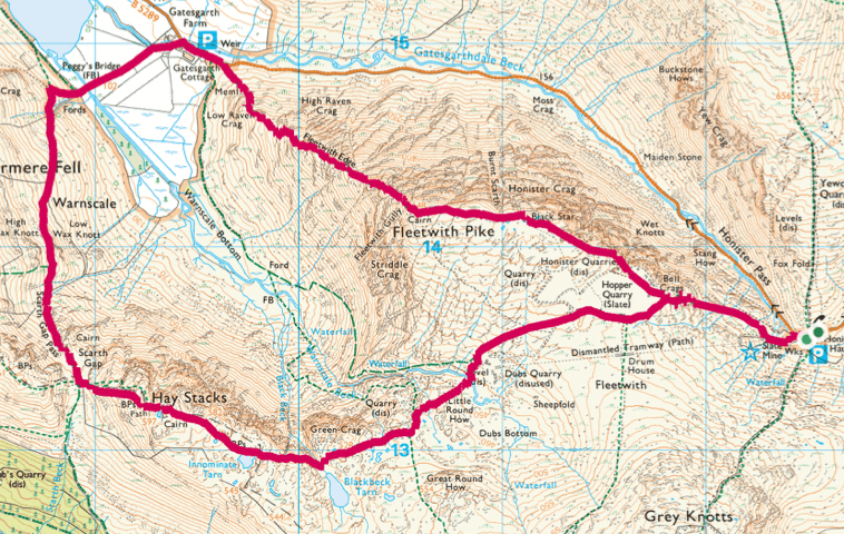
Haystacks + Fleetwith Pike hike
Walk location: Near Buttermere and Seatoller
Start point: Honister Hause YHA – Car Park NY 22550 13534
Route length: 6.5 miles/ 11 km
Total ascent: 1,142 m/ 3,747 ft
Hiking time: 4-4.5 hours
Hike difficulty: Moderate/Challenging
Wainwrights: 2 – Fleetwith Pike and Hay Stacks
Haystacks + Fleetwith Pike Map
On my Lake District trip, I did this route from YHA Borrowdale which added an extra 4 miles/6 km to this walk. However, in my opinion, this route is the best bit of the walk starting at Honister Pass near the Slate Quarry.
Don’t be deceived by the distance, although a short walk, this one involves a lot of up, down then up and down again! A walk I’d recommend to take hiking poles if you have them.
From Honister Pass, which you might want to take some time to explore and take photos before the walk you then head straight up.
It’s approximately 2 km to the summit of Fleetwith Pike, but that’s 2 km of nearly 300 metres ascent!
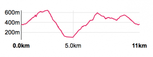
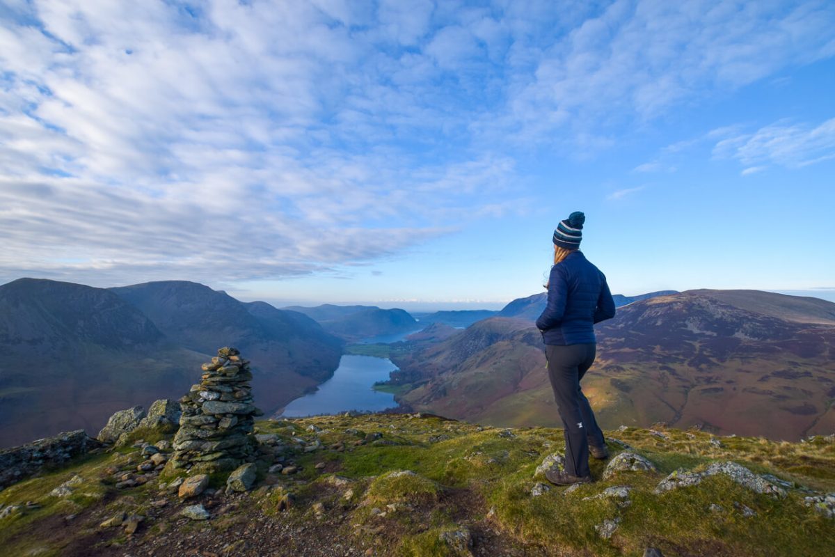
The views are epic when you reach the top though. Stop, enjoy, chill out and eat food, of course! Descending Fleetwith Pike into Buttermere is the next stage. This is even steeper than the route up, taking the path called Fleetwith Edge.
Over 500 metres descent in 1.5/2 km.
Check out on the picture above! See, I’m not exaggerating!
If you really don’t like steep descents then you could swap the route around. I will let you decide!

Once you reach the bottom, it’s a short flat section, before going up again. I did mention this was an up and down route! But don’t forget to check out the great views of both Fleetwith Pike and Hay Stacks.
Hay Stacks or Haystacks is not as steep but has a few sections that you need to watch your footing. Along the path there are a couple of tarns then you make your way, back downhill to the start point.
Yes, your legs might ache tomorrow but wow, what a gorgeous walk this is.
Let me know if you do it and which direction you did the walk!
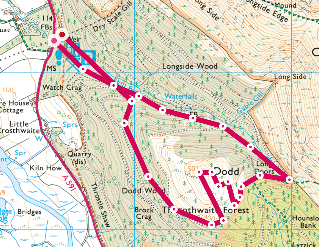
Dodd Fell walk

Walk location: Dodd Forest (near Keswick)
Start point: Off A591 Car Park – NY 23546 28185
Route length: 3 miles/ 5 km
Total ascent: 391 m/ 1,282 ft
Hiking time: 1.5-2 hours
Hike difficulty: Easy/Moderate
Wainwrights: 1 – Dodd
Dodd Fell Map
Best things come in small packages, right? Well, this beautiful walk in the Lake District is perfect for everyone to enjoy.
On the day I hiked to the top there were many families with children also taking the same route to the top.
There’s a good trail that leads up to the summit, both easy to walk and navigate as well.
And once you reach the top there’s plenty of space for a picnic and to enjoy views over nearby Bassenthwaite Water and in the distance Derwent Water.
Extend the walk

Route length: 7.5 miles/ 12 km
Total ascent: 1,095 m/ 3,592 ft
Hiking time: 4-4.5 hours
Hike difficulty: Moderate/Challenging
Wainwrights: 4 – Dodd, Carl Side, Skiddaw and Ullock Pike
Dodd Fell including Skiddaw Map

Fancy extending this beautiful walk in the Lake District. Well, if it’s a beautiful day then I’m sure you’ll be tempted!
From Dodd, return down the same path to the main track then instead of heading back down to the car park take the path heading upwards to Carl Side.
And from there on a clear day, you’ll see the very steep path leading up to Skiddaw summit. It’s a bit of a trek and you might need to stop once or twice but of course, once you reach the top its all worth it.
Skiddaw summit is pretty big, perfect for a huge group photo. There’s also a small stone shelter you can shelter behind on a windy day but it’s fairly exposed so make sure you have some warm clothes to put on at the top.
From the summit, return back down towards Carl Side.
The next section I didn’t walk myself but a fellow hiker recommended it and it looked amazing. It’s more of a ridge so if you aren’t keen on steep downhills then reverse this route so you walk up (and not down) it.
Great Gable via Grey Knotts + Kirk Fell

Walk location: Near Rosthwaite
Start point: Honister Slate Mine
Route length: 8 miles/ 12.5 km
Total ascent: 1,275 m/ 4,183 ft
Hiking time: 4.5-5 hours
Hike difficulty: Moderate/Challenging
Wainwrights: 5 – Grey Knotts, Brandreth, Green Gable, Great Gable, Kirk Fell
Great Gable via Grey Knotts + Kirk Fell Map

This might seem like a short walk, but there’s a fair bit of up and down so be prepared for a challenge. Starting at Honister Pass gives you a leg up, but there are some good uphill sections for this length of the walk.
From Honister Pass, you head straight up to Grey Knotts, from there you follow the path along to Brandreth and Green Gable with views to Buttermere and Ennerdale Water to your west.
Green Gable to a great place to stop for a breather and a few snacks, before heading down a short rocky section before heading back up again to Great Gable. You can stop and admire the dome or pudding shape mountain as it’s fondly known.
The path to Great Gable has some loose stones and a short scrambly section but after some hard work, you’ll make it to the top. On a clear day, you can see across to the Isle of Man and Scotland!
From the summit, this route takes you up one more fell, Kirk Fell, which is equally as beautiful, before heading back down, then up, then down again to the start!
I did say there were a lot of ups and downs!
Read the route here + three other great hikes around Borrowdale
OL5 – Best Walks in the Lake District
(Ordnance Survey Map – North-eastern area (Penrith, Patterdale & Calbeck)
Angle Tarn

Walk location: Near Patterdale + Ambleside
Start point: Cow Bridge Car Park
Route length: 7 miles/ 11 km
Total ascent: 716 m/ 2,349 ft
Hiking time: 3.5-4.5 hours
Hike difficulty: Moderate
Wainwrights: 0 but close to 1 – (Angletarn Pikes)
Angle Tarn Map

Angle Tarn is a real treat, it’s unlike any other tarns I’ve visited with a population of Canadian Geese also enjoying the location.
The tarn is fairly large with a backdrop of mountains that you can see between the hills and on the walk to the tarn, how beautiful.
The walk starts gradually but pretty soon you have a steep uphill climb. I remember it well as I was hiking with my big rucksack at the time. But once you reach the top you can catch your breath and some gorgeous views as well.
Be sure to look across to see Helvellyn and the full mountain range to your left, as you walk along the path towards the tarn.
Once you reach the tarn you can walk close but the ground is a little boggy in some areas, especially if it’s been raining, so watch your step!
The path is fairly obvious for most of the route, which the one exception when the path splits to go up Rest Dodd.
Look out for the path as it’s not 100% clear. (The DofE group out on the same day missed it and ended up doing an extra hill on their hike so don’t make the same mistake!)
Extend the walk

Route length: 8 miles/ 12.5 km
Total ascent: 906 m/ 2,972 ft
Hiking time: 4.5-5 hours
Hike difficulty: Moderate/Challenging
Wainwrights: 3 – Angletarn Pikes, Rest Dodd and The Knott
For those, who love Wainrights too there are a few that you can ‘bag’ on this walk if you extend it slightly. As you walk towards the tarn on the left there are Angletarn Pikes, literally an extra climb up and you’ll be at the top.
Aparently, there are two summits, so you need to do them both (I will let you decide!)
Then on the walk around, you have the option to hike up Rest Dodd (696m), I have no idea why it’s called this other than after that hike up you need a rest!
Once at the top you can descend the other side (sheep track) that takes you back onto the route. Then if you fancy another Wainright you can extend the walk again (and hike uphill) The Knott (739m).
By doing this you’ll only add approximately an extra mile onto your total work, but as well as the distance it’s another 200 m ascent to factor in too!
Extend the walk (Again)

Route length: 16 miles/ 26 km
Total ascent: 1,698 m/ 5,570 ft
Hiking time: 8-9 hours
Hike difficulty: Challenging
Wainwrights: 6 – Angletarn Pikes, Rest Dodd, The Knott, Rampsgill, High Raise, Beda Fell/Head
Angle Tarn via High Raise Map

Or for the super route, this is the one I did but I split it up with a wild camp on the route so I didn’t do the full distance in one go.
This takes you on a great big and wonderful circular route, including the highest point on the route High Raise at 802m.
Then you pretty much hike all the way down, to ultimately go all the way back up again haha
Then back round over Beda Head and Beda Fell which for me were my favourite views of the day across to Ullswater in the distance.
But they were all pretty awesome so I can’t complain!
Blencathra walking routes

Walk location: Near Keswick
Start point: Scales Car Park or layby parking available along A66
Route length: 5 miles/ 8.5 km
Total ascent: 881 m/ 2,890 ft
Hiking time: 3-3.5 hours
Hike difficulty: Moderate
Wainwrights: 1 – Blencathra
From the A66 you can park and be up to the top of this awesome mountain in a couple of hours. Sounds like an offer you can’t refuse! It’s pretty much uphill route the terrain is good, although in the wet be careful of the rocks as they can be slippery.
This path takes you down to Scales Tarn where you have some great views hiking up the path to Blencathra summit.
The path up to the summit is fairly steep but once you reach the top, providing the cloud hasn’t dropped in you’ll have some gorgeous views to enjoy.
Be sure to get a selfie with the new trig marker, organised by John from @robustours after the last one went strangely missing 🙁
Try a Different Blencathra Route

Route length: 5 miles/ 8 km
Total ascent: 1,125 m/ 3,690 ft
Hiking time: 3-3.5 hours
Hike difficulty: Difficult
Wainwrights: 1 – Blencathra
Although the distance is pretty similar, you may notice the total ascent has increased, argh, but it’s worth it.
This route also includes two ridge section, depending on which direction you do it in, there’s Hall’s Fell then Sharp Edge. I hiked up Hall’s Fell, then back down Sharp Edge but it’s beautiful in both directions.
If you suffer from vertigo this might not be the route for you.
Feel free to message me if you have any questions.
Important
In wet weather, the rocks get super slippy. I walked up to Scales Tarn in a light shower and I could already notice the difference on the flat rocks. Personally, I would opt to do a different route in these conditions. Firstly, it’s safer, and secondly, you’ll enjoy it a lot more!
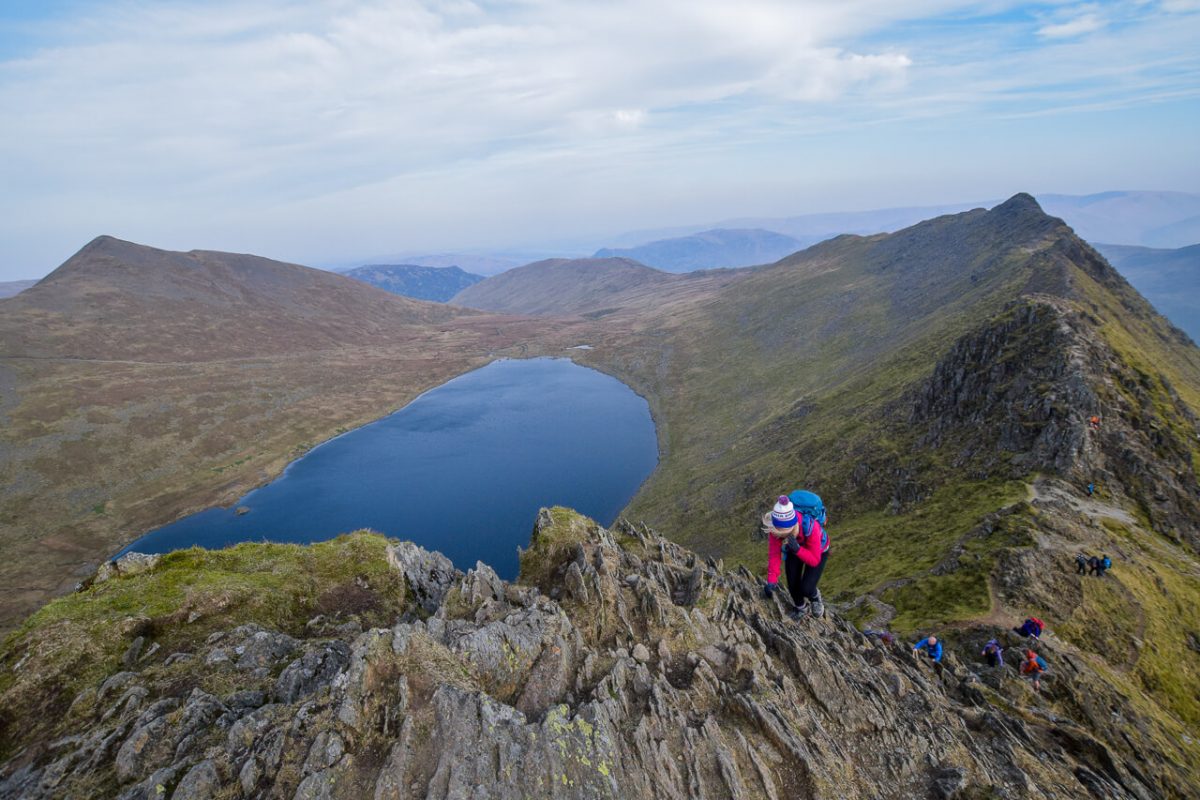
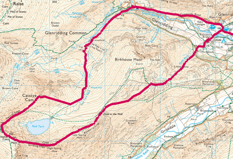
Helvellyn + Catstye Cam (via the edges)
Walk location: Glenridding (near Patterdale)
Start point: Glenridding Car Park
Route length: 7 miles/ 11.5 km
Total ascent: 1,069 m/ x ft
Hiking time: 4-4.5 hours
Hike difficulty: Moderate/Challenging
Wainwrights: 2 – Helvellyn and Catstye Cam
Helvellyn + Catstye Cam Map
Helvellyn walk via Catsyte Cam is definitely one of my top walks in the Lake District.
I’ve hiked it a couple of times and each time it brings with it wonderful memories and views. Well, apart from my very first time hiking the long-distance Coast to Coast path when it was covered in cloud haha!
This walk offers a few extra challenges, walking along the popular Striding Edge the ridge leading up to Helvellyn, before the final scramble to the top (@blonde_on_a_mountain pictured above).
Helvellyn is a popular walk because of the views and ridges that you walk along.
However, Catstye Cam is less-popular so it’s common that even though Helvellyn will be busy you might be able to enjoy Catstye Cam summit to yourself.
And those views are pretty amazing.
Helvellyn has many different routes up and down so if you don’t fancy a challenge then check out one of the other options
Read here Helvellyn versus Scafell Pike
Arnison Crag walk

Walk location: Patterdale
Start point: Patterdale Hotel
Route length: 9 miles/ 15 km
Total ascent: 1,209 m/ x ft
Hiking time: 4-5 hours
Hike difficulty: Moderate
Wainwrights: 4 – Arnison Crag, Fairfield, Hart Crag, Hartop Above How
Arnison Crag Map

A walk close to the popular Helvellyn, but without the crowds! Want to enjoy a beautiful quiet Lake District walk then I’d recommend this one.
I hiked this route plotted by @jamesmichaelforrest on a busy weekend with some fellow hiking Instagrammers (too many to mention) But a few of them are included in my favourite hiking Instagram accounts.
This walk, takes in some great fells, including Fairfield and Hart Crag, which also make fantastic picnic spots too!
This is a great walk to combine with Helvellyn if you’re visiting the Lake District for the weekend.
OL6 – Best Walks in the Lake District
Ordnance Survey Map – South-western area (Coniston, Ulverston, & Barrow-in-Furness)
Scafell Pike hike

Walk location: Wasdale (near Wast Water)
Start point: Wasdale Head
Route length: 7 miles/ 11.5 km
Total ascent: 1,117 m/ x ft
Hiking time: 3.5-4 hours
Hike difficulty: Moderate
Wainwrights: 1 – Scafell Pike
Scafell Pike Map

Another classic, Scafell Pike is the highest mountain in England so I couldn’t miss it off the best hikes in the Lake District list!
Like most fells and mountains in the Lake District, there is more than one route to the summit. I’ve only hiked up this mountain once, and I managed to pick a gorgeous day so not sure I should tempt fate and do again haha!
Wasdale Head is a popular start point for the hike, but you can also start from Seatoller too and join up with this route.
The route I’ve shared takes you up via the Corridor route, which is slightly longer than going up and down Hollowstones. But if you like a circular route then this is a great way round to do it.
I stayed in a camping pod at nearby Boot at Eskdale Campsite which is a great location to base yourself from for this walk.
From Boot, you can also catch the steam train (or walk) to nearby Ravenglass. You can read the route I took here.
Bowfell + Crinkle Crags Fells

Walk location: Near Langdale
Start point: Great Langdale car parks (2 to choose from)
Route length: 9 miles/ 15 km
Total ascent: 1,327 m/ 4,353 ft
Hiking time: 3.5-4 hours
Hike difficulty: Moderate
Wainwrights: 4 – Bowfell, Crinkle Crags, Cold Pike and Pike of Blisco

This ‘best walk’ is one of my favourite walks to date, it’s possibly because of the name Crinkle Crags, it even sounds fun! Or maybe my comedy hiking buddy that day @summits_with_saul.
The start the walk first takes you up to Bowfell, a mountain over 900 metres, clocking in at 902m!
Of course, this means some stunning views from the summit, including Scafell Pike!
From Bowfell you take the route down across Crinkle Crags. Yes, they are exactly as they sound, crinkly haha.
There are a few sections where you need to scramble a bit, with one technical bit, there isn’t a huge drop but you might find it challenging. You can go around but take your time and you can descend safely.
From there you can pop up Cold Pike and Pike of Blisco for epic views to complete your wonderful Lake District walk.
Pavey Ark
View this post on Instagram
Walk location: Near Langdale
Start point: Great Langdale car parks (2 to choose from)
Route length: 3 miles/ 5 km
Total ascent: 671 m/ 2,201 ft
Hiking time: 2-2.5 hours
Hike difficulty: Moderate
Wainwrights: 1 – Pavey Ark
Pavey Ark Map
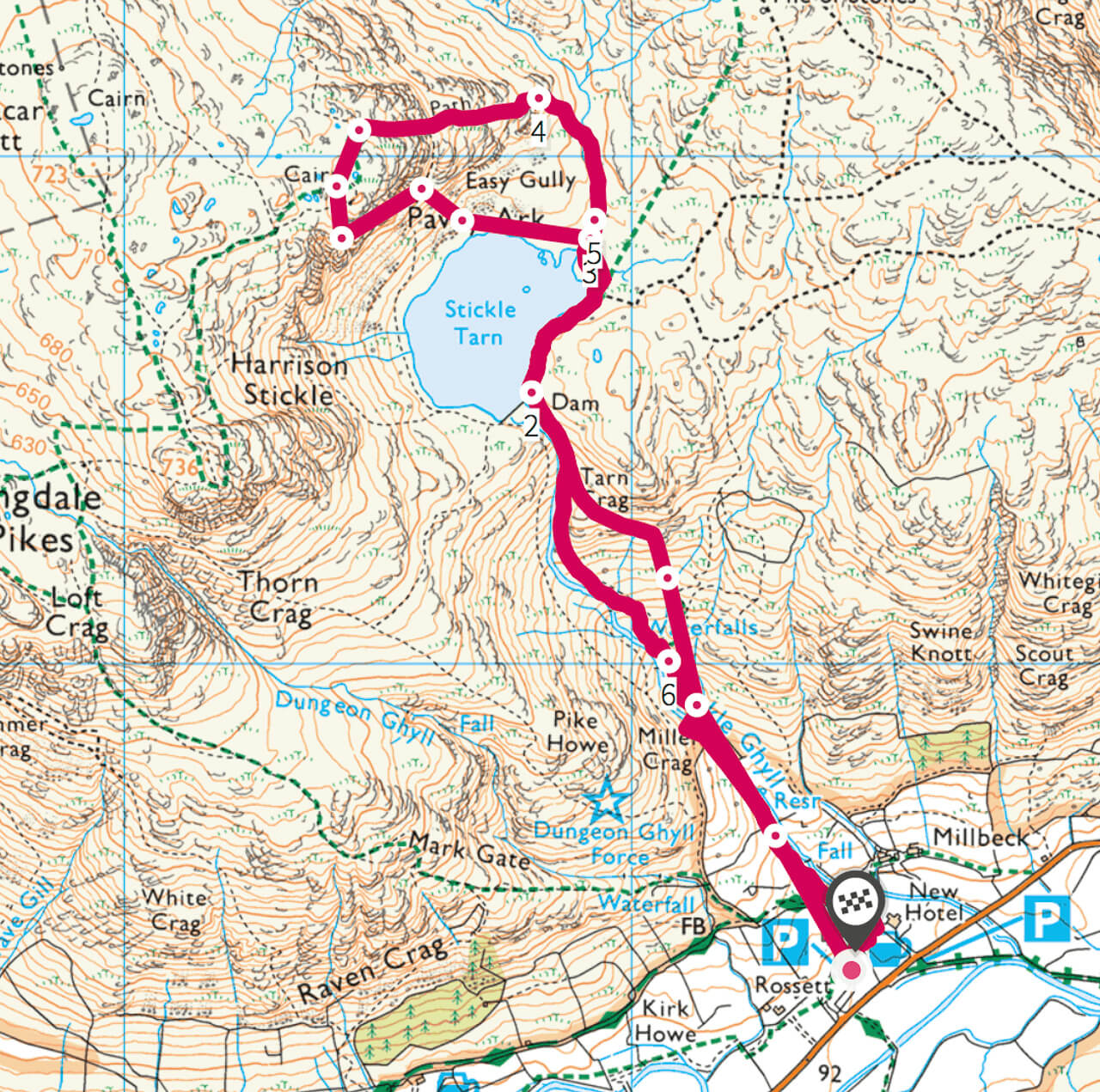
This is a wonderful fell to hike, with a couple of options, depending on whether you fancy a fun (and challenging) scramble via Jack’s Rake.
That’s me having fun up Jack’s Rake. I seem to have lost all the other photos from that day! Probably because it was a special lady’s last Wainwright walk (@adventurer.nic) so I was too busy chatting!
But I promise it’s a beautiful walk!
From Langdale Valley you descend up Stickle Ghyll, a narrow stream trickling down the mountain. Or in heavy rain, I can imagine more of a torrent of water haha! Pick your day to do the hike!
At the top of the stream, you’ll reach the source, Stickle Tarn, which in my opinion is awesome before you even reach the top, surrounded by some beautiful fells you begin to feel very small, but in a good way.
Here’s where you have a choice. Hike up via Jack’s Rake, a grade 1 scramble, in wet conditions there are some parts that can be quite tricky. Or alternatively, continue up via the footpath which heads north then curves round west to the summit.
OL7 – Best Walks in the Lake District
Ordnance Survey Map – South-eastern area (Windermere, Kendal & Silverdale)
Great Rigg + Heron Pike walk

Walk location: Near Grasmere and Rydal
Start point: White Moss Car Park
Route length: 8 miles/ 13 km
Total ascent: 1,312 m/ 4,304 ft
Hiking time: 4 hours
Hike difficulty: Moderate
Wainwrights: 3 – Great Rigg, Heron Pike, Nab Scar
Great Rigg + Heron Pike Map

Another beautiful Lake District walk, of course, they are all wonderful! From White Moss Car Park you make your way up through the woods. You can also start the walk from nearby Grasmere.
Then follow the trail up to the first great lookout point at Grey Crag. It’s definitely worth a stop here to enjoy those Lake District views.
From the Crag continue heading north, past the small tarn and then start heading down slightly. There is an option to head directly up to Heron Pike, but this is a seriously steep route.
Unless you short on time I would opt for the longer option with a more gradual ascent to the top of Great Rigg.
Then from here you simply follow the path south to Heron Pike and continue down with views over Rydal Water.
Rydal Water + Rydal Cave walk

Walk location: Near Grasmere and Rydal
Start point: White Moss Car Park
Route length: 3 miles/ 5 km
Total ascent: 154 m/ x ft
Hiking time: 1.5-2 hours
Hike difficulty: Moderate
Wainwrights: 0
Rydal Water + Cave Map

Rydal Water is a perfect walk for everyone to enjoy in the Lake District.
From the road, there is parking both sides at White Moss walks car park (automatic registration detection that you pay on departure).
In spring as you walk through the woods you’ll see a scattering of beautiful bluebells before reaching the path alongside Rydal Water.
As you walk along the path, be sure to head up to Rydal Cave. A huge cave that you can actually walk straight up to and go inside to explore.
You can either walk the same route back or head into Rydal and follow the wooded path on the other side of the road before returning to your start point.
You can read about my full weekend in the Lake District where I did this hike here.
Kentmere Horseshoe (or Kentmere Round) hike
Walk location: Kentmere (near Staveley)
Start point: Kentmere
Route length: 13 miles/ 21 km
Total ascent: 1,322 m/ 4,337 ft
Hiking time: 7-7.5 hours
Hike difficulty: Moderate/Challenging
Wainwrights: 7 -Shipman Knotts, Kentmere Pike, Mardale Ill Bell, High Street, Froswick, Ill Bell, Yoke
Kentmere Horseshoe (or Kentmere Round) Map

This is one of those iconic Wainright routes and I was lucky enough to hike it on a good weather day and get epic views! You can’t beat a good horseshoe route, one because it means you get to start and finish in the same place but the whole route is awesome.
For a Wainwright bagger, you can certainly tick off a few fells on this walk. You can also add in Thornthwaite Crag as well, which is slightly off the route.
From Kentmere, you climb up to the first summit Shipman Knotts, then continue along to Kentmere Pike. The halfway point is High Street, which I found highly amusing that a mountain can be called.
Top tip
If you want to do this at sunrise, (highly recommended), even though I’m terrible in the mornings then it’s best to do the horseshoe in an anti-clockwise direction.
Want to experience the Kentmere Valley without going up all the hills?
Then check out my next walk, Kentmere Reservoir.
Kentmere Reservoir walk

Walk location: Near Staveley
Start point: Kentmere
Route length: 7 miles/ 12 km
Total ascent: 588 m/ x ft
Hiking time: 3-3 hours
Hike difficulty: Moderate
Wainwrights: Views of lots (in good weather)
Kentmere Reservoir Map

Whilst staying at Kentmere Farm Pods, I wanted to go out and explore the area. For some reason, it had decided to rain on me and the clouds were hovering on the hilltops so a low-level walk seemed like the best choice.
From Kentmere, you can take a relatively straightforward walk all the way to Kentmere Reservoir. On a clear day, I can imagine you’d get awesome views of the peaks on the Kentmere Horseshoe route as well. But not the day I walked it!
Just because it’s raining doesn’t mean you can’t enjoy the outdoors. I met plenty of other walkers wearing full waterproofs and still having a good time!
On reaching the reservoir, the path starts to take you round in a clockwise direction. But half-way up, as you can see from the map the path kind of disappears. I wanted to extend my walk so continue further up, planning to cross the water.
But heavy rain and a wide stream rushing down the mountains, didn’t look appealing. There was no path on the other side either.
Back at the bottom of the reservoir you can cross a bridge, and follow the path along the other side of the River Kent almost all the way back into Kentmere.
Lake District hiking tips

What to Take on a Day Hike?
I’d always recommend taking a small backpack with a few essential items. Even on a sunny day, in the Lake District, the weather can change really quickly so it’s best to be prepared.
- Waterproofs
- Water + snacks
- First aid kit
- Map + compass
For my full detailed list of what to wear and what to take on a day hike, you can click here to read what I recommend. Or you can check out my shop for recommendations of the kit and gear I use and wear.
More UK Hikes
There are plenty of more beautiful places to go hiking in the UK. You’ll be amazed by how much you’ve not explored yet!
Here are a few of my other favourites walks and places to visit to enjoy the outdoors:
- Jurassic Coast in Dorset
- Edale in the Peak District
- Brecon Beacons National Park
- 25 awesome day walks in the UK
Have you been walking in the Lake District? What do you think of my selection best walks in the Lake District so far?
Thanks for the inspiration! Roll on summer
Thanks Simon, I’m with you on that 🙂