Are you looking for the best walks to do in the Brecon Beacons? Maybe you’re visiting for a short trip and want to make the most out of your time.
The Brecon Beacons National Park makes up one of three National Parks in Wales and as with all the National Parks in the UK, there are plenty of amazing walks to do.
It was the last National Park that I visited in Wales on my UK Hiking Challenge. And in 3 days, walking in the Brecon Beacons took my breath away with its stunning landscapes and views
But planning a 3-day walking trip can be overwhelming if you’re new to the area so here are some of the best walks in the Brecon Beacons!
walking in the Brecon Beacons took my breath away
The Brecon Beacons in South Wales
The walks in this 3-day itinerary fit with the location where I was staying, east of the National Park.
During my three day trip in the Brecon Beacons, I stayed at the Star Bunkhouse in a village called Bwlch, located near the centre of the National Park.
Then on to the larger town of Abergavenny at the Angel Hotel which is outside the east boundary of the Brecon Beacons. Both are wonderful places to base yourself for some epic exploring of this National Park.
This is the 3-day walking itinerary of my best walks in the Brecon Beacons.
Also included you’ll find the walk grid reference, where to park at the start of your walks, how far and how long each walk will take, plus the OS map for each walk. As well as my useful hints and hiking tips so you enjoy your time in the Brecon Beacons. 🙂

Walking in the Brecon Beacons Itinerary
Day 1 walks
Craig Cerrig Gleisiad
Corn Du, Pen y Fan and Cribyn
Day 2 walk
Day 3 walks
More walks in the Brecon Beacons
A few facts about the Brecon Beacons National Park*
Before you read about these awesome walks in the Brecon Beacons, here are a few fun facts.
How many do you know?
- The Brecon Beacons was designated in 1957
- It is 1,344 sq km/ 835 sq miles
- And has a population of 32,000
- The highest point is Pen y Fan at 2,907 ft/ 886 m (the most popular walk)
- Each year over 4.1 million people visit the Brecon Beacons National Park
Want to read later? Save to Pinterest here
![]()
Walks in the Brecon Beacons: Day 1
Craig Cerrig Gleisiad morning hike

Walk distance: 3.5 km/ 2 miles
Time: 1-1.5 hours
Map: OS Explorer OL12 – Brecon Beacons National Park West
Starting Grid reference: SN 971 222
Parking: Lay-by on the west side of A470 (Merthyr Tydfil to Brecon Road)
This is a lovely steep short circular walk, with some breathtaking views of the Brecon Beacons including Pen y Fan (which I hiked later the day). And demonstrates the fascinating history of this area in the Brecon Beacons.
Back in the ice age, a glacier carved out the valley. And as it melted about 18,000 years ago it exposed the steep rock walls of Craig Cerrig Gleisiad.
Several years later, there were many landslides where rocks cascaded down. Up until 11,500 years ago, there was also a smaller glacier, which has now left a series of small ridges of rocks and debris called moraines.
The hollow from the glacier is now a bog at the base of Craig Cerrig Gleisiad! Better to avoid on your walk!

After you’ve walked through the gate, you have two choices, right or left. I took the path on the right which takes a steeper route directly up to the ridge.
Alternatively, you can opt for a more gradual walk up on the left. I would rather hike up a steep slope than attempt to walk down it, especially as the paths are muddy and slippy. Take care hiking on the way up (and down!)
Once you’ve reached the top of the ridge there are wonderful views of the Brecon Beacons.
This is one of the best walks in the Brecon Beacons for looking across to Pen y Fan, the highest point in the National Park.
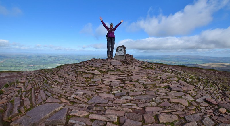
An afternoon Hiking the Brecon Beacons three peaks – Corn Du, Pen y Fan and Cribyn

Walk distance: 10.5 km/ 6.5 miles
Time: 3-4 hours
Map: OS Explorer OL12 – Brecon Beacons National Park West
Starting Grid reference: SN 988 199
Parking: ‘Pont ar Daf’ lay-by or Story Arms down the road on A470
Pen y Fan is the highest mountain in South Wales and a popular day hike in the Brecon Beacons National Park (some say it’s the best walk in the Brecon Beacons but I will let you decide).
Setting off from Pont ar Daf you can see the path leading to the summit straight away.
a popular day hike in the Brecon Beacons National Park
At Pont ar Daf car park, there is a mobile refreshment stand serving hot drinks and food. Then you can begin your hike up the main path. The Pen y Fan walking route I did was a circular walk but you can also hike up and down the same route via this path.
Before you reach the top of Pen y Fan (886 m/ 2,907 ft), the path takes you up to the second highest mountain in South Wales Corn Du (873 m/ 2,864 ft). It’s two mountains for the price of one!

Extra walk option
If you want to shorten your hike, maybe if the weather isn’t good or your legs have given up on you! You can miss out the hike up and down Cribyn (795 m/ 2,608 ft).
But I really loved this extra hike, it’s not as high as Pen y Fan or Corn Du but it gives you some gorgeous views looking back.
It’s about 3 km so an extra 45 minutes walk but on a beautiful sunny day, it gives you the best views of Brecon Beacons.
You might like to read – Attempting the Welsh 3000s Challenge in Snowdonia
Walks in the Brecon Beacons: Day 2
Llangors Lake circular walk (Bwlch with Altitude)

Walk distance: 19 km/ 12 miles (Extended walk – 21 km/ 13 miles)
Time: 5-6 hours
Map: OL13 Brecon Beacons National Park East
Grid reference: 14869 22020
Parking: Street parking (limited options – Darren Road or by the A40/B4560 junction by The Gate Shop & Bwlch Village Hall)
This circular walk starts from The Star Bunkhouse, with a steep climb up. But after 10 minutes of walking it is all worth it as you reach the top and make your way along the ridge, the views are stunning.
Walk straight along the path, past several turnings for bridleways. The path then curves around to the left as you head up to the summit where there’s a very fancy trig point! It takes about 45-60 minutes to reach here.
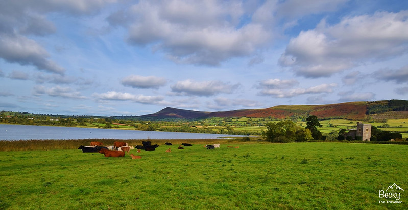
Continue along the ridge and look out for wild ponies on the path. A group appeared from the lower slopes but were friendly enough. It’s about 30-40 minutes following the ridge down to reach the road.
Of course, depending on how many photos you take of Llangors Lake on the way!
This is an easy section of the walk, on the road for about 30 minutes. At the next road junction, green area turn right. Past the Castle Inn until you reach the Church. It’s a short walk across a field fields (5-10 minutes), with the wire fence on your right until the lake comes into view.
Shortly followed by the only public toilets on the walking route!
Read next – How many of these things have you done whilst hiking?
Lunch stop
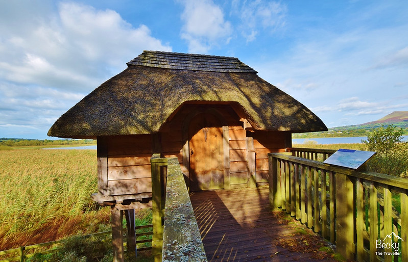
I went on a detour here, exploring the boathouse, instead of walking across the field to the footbridge. But it was interesting to look around and only adds a few minutes to your circular walk!
Across the bridge, there’s a ‘sound machine’! You can listen to Reed Warblers and various other birds. Continue on for 15-20 minutes and you’ll come across a lovely bird hide.
Through a gate and field of cows (they were there when I walked) you’ll reach the church after 15-20 minutes. As you walk towards it look up to see the ridge you walked along at the beginning of the walk.
This is a beautiful building and worth 5 minutes to stop a look inside.
Follow the country lane up for 10 minutes until you reach a right turn signposted to Pennorth 1-mile. After a relatively flat section of the route, you’ll hike back up high again for views back over the lake.
Don’t forget to look behind you as you walk at the Brecon Beacon views!
This section takes about an hour until you’re back onto the main road taking you into Bwlch. There’s a small section where there’s no pavement and you need to walk on the edge but soon The Star Bunkhouse and The New Inn pub come back into view!
Further reading for walks in Wales
More walks from Bwlch, Brecon Beacons
This is one of three local walks from Bwlch, from the walk leaflet from The Star Bunkhouse where I was staying.
Each walk leaflet costing 20 pence. They include a very detailed map and directions for your hike. I was told this was the best walk out of the three options but maybe you can tell me if you try the other two hikes below!
The two additional walks
1. Bwlch with Fortitude (12 km/ 7.5 miles)
2. Bwlch with Magnitude (10.5 miles)
Read next: Why is the West Highland Way an amazing trail (plus tips)?
Walks in the Brecon Beacons: Day 3
Hike 1 – Sugar Loaf Hill in the Brecon Beacons

Walk distance: 5 km/ 3 miles
Time: 1.5-2 hours
Map: OL13 Brecon Beacons National Park East
Starting Grid reference: 269 167
Parking: Sugar Loaf Car Park (nearest postcode NP7 7LA)*
*This postcode doesn’t take you directly to the car park. Please use as a guide. Follow the signs for Sugar Loaf Vineyard and then continue 1.5 miles uphill
There are many routes up and down Sugar Loaf. I opted for a slightly more challenging walk up. Taking a downhill path off the main path into some woods with very cool twisted trees. Before then had a steep uphill climb.
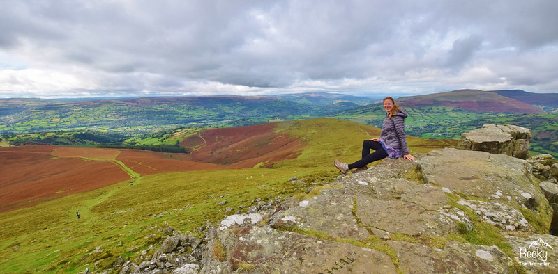
However, you can opt for a steadier incline and decline if you opt for the wider paths. On a clear day, you can see dots in the distance of people making their way up and down to the summit. This is a very popular Brecon Beacon walk at the weekend.
The great thing is you can go up and down different routes and end up at the same start point without going on too much of a detour. The picture shows one of the main paths leading to the summit.
You can walk along the top and come down the other path on the left. Both paths join at the point where I took the photo.
Want to know what hiking tripods I use on my solo hikes?
Hike 2 – Blorenge walk

Walk distance: 10 km/ 6 miles (shorter options available)
Time: 2-3 hours
Map: OL13 Brecon Beacons National Park East
Starting Grid reference: 263 108
Parking: Foxhunter Car Park – (nearest postcode NP4 9SR)*
*There is no postcode for the car park, this is the nearest one. If you follow it all the way it will take you past the turning. My best advice is when you are close look out the radio masts you can see from the main road.
The hike takes you there and back on the same path. Perfect as you can design how long your walk is. On leaving the car park there’s a path that takes you straight to the trig point.
And on a clear day, you should see this from the Foxhunter car park. Make sure you stop here for a few photos.
Then continue along the path on the other side of the trig point. This is where it starts to get a bit muddy. Mini-detours or some good jumps are required to get you around (without getting too dirty – unless you like that kind of thing!)
Keep walking for about 30 minutes until you are met with beautiful views across the Brecon Beacons (again on a good day!)
You should be able to see across to Sugar Loaf.
This is definitely one of the best shortest walks in the Brecon Beacons, with awesome views!
Read next: Ben Nevis Walk in Scotland – Hiking solo up UK’s highest mountain!
Extended option
At this point, you have the option of returning back to the car park or continuing. If you keep walking, it is downhill now. Fantastic you might think, but do remember that you will need to walk back up again. Yes, I didn’t factor this into my walk!
Take the path down until you reach a road and a cattle grid. To the left of the cattle grid there’s a gate and after 100 metres another gate on your left.
Walk down through the woods until you reach a pond. It’s very peaceful at the pond, a few ducks and sheep to keep you company. And this is your turnaround point. It took me about an hour to do reach the pond.
And now the easy (or maybe difficult bit) retrace your steps, back uphill to Foxhunter car park. I’m a fast walker so managed to get back in an hour but for a more leisurely pace allow 1.5 hours.
More walk ideas in the Brecon Beacons
Planning a longer trip to the Brecon Beacons. Here are some more wonderful walks you can do in the National Park.
Four Waterfalls Walk
Walk distance: 6.5 km/ 4 miles
Time: 2-2.5 hours
Map: OS Explorer OL12 – Brecon Beacons National Park West
Starting Grid reference: SN 928 124
Parking: Cwm Porth, Ystradfellte, Aberdare, CF44 9JF (Not exact postcode)
A short but very popular walk in the Brecon Beacons. If you love waterfalls, and who doesn’t then this is a must-do walk.
The trail takes you through the woods, coming across the various waterfalls as you go. And you can even go explore behind one of the waterfalls if you’re brave enough and don’t mind getting a bit wet!
The best time to do this walk is on a rainy day (or the day after) because the falls are really flowing and look spectacular.
Fan y Big Walk
Walk distance: 11 km/ 7 miles
Time: 3.5-4.5 hours
Map: OS Explorer OL13 – Brecon Beacons National Park East
Starting Grid reference: SO 057 175
Parking: Blaen y Glyn Isaf, Merthyr Tydfil CF48 2UT
A great circular walk from near Talybont Forest, that takes you up to Fan y Big hill in the Brecon Beacons. Follow the Beacon Way trail up and then loop back down until you meet the Taff trail.
On a clear day, you can see the highest summit in South Wales, Pen y Fan. Another great walk you can do on your visit to Wales!
Be sure to take the iconic photo stood (or sat) on the jutting out ledge!
Talybont Forest + Waterfalls Walk

Walk distance: 2 km/ 1.3 miles
Time: 1-1.5 hours
Map: OS Explorer OL13 – Brecon Beacons National Park East
Starting Grid reference: SO 062 170
Parking: Talybont-on-Usk, Merthyr Tydfil, CF48 2UT
The car park starting point for this walk is not far from the Fan y Big walk.
You can fit this walk in as a short morning or evening walk and still see lots of beautiful scenery without too much effort.
From the car park head down the road before reaching the footpath, from here you can walk up one side of the stream, then further up cross a small bridge to return the other side.
There are several small waterfalls on this short section of the trail.
What to wear for your day hike in the Brecon Beacons?
The weather can quickly change when you are hiking in the Brecon Beacons (or anywhere in the UK). It’s best to be prepared with warm and waterproof gear.
Also, good hiking boots are essential to make sure you have a great day out and enjoy your walk.
Read my full guide on what to pack for your day hike including what to wear.
Further information about the Brecon Beacons

More things to do in the Brecon Beacons
The Brecon Beacons is a huge playground if you love the outdoors, as well as gorgeous walks there are plenty more adventurous activities that you can take part in.
Here are a few other things you can do in the Brecon Beacons
- Rock climbing and abseiling
- Mountain biking
- Horse riding
- Exploring caves underground
- Watersports – sailing, windsurfing
Check out the 25 Best Places to Visit in Wales on a Road Trip
Where to stay in the Brecon Beacons?
The Star Bunkhouse Bwlch
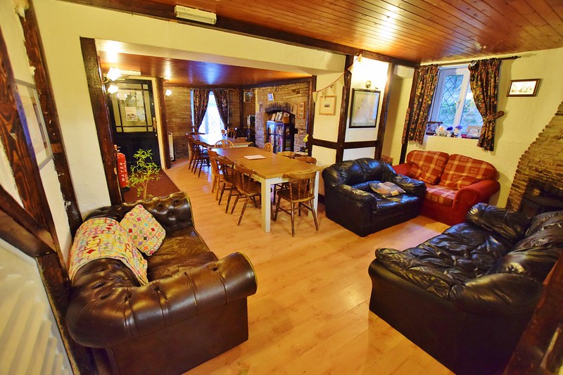
I stayed for my first two nights at The Star Bunkhouse in Bwlch. A lovely bunkhouse with six rooms and a shared lounge and kitchen. Perfect for groups, families and solo travellers (like me!). And they allow dogs too.
Great if you are travelling on a budget as it’s self-catering so you can save money by not eating out.
To find out more about The Star Bunkhouse read my full review here.
The Angel Hotel Abergavenny
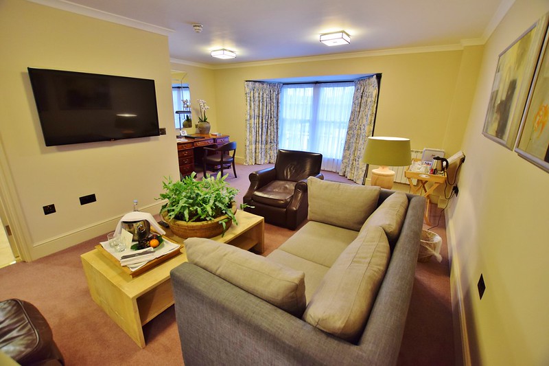
My third night was spent in the town of Abergavenny at The Angel Hotel.
Perfectly matched my name so I had to stay there! A luxury boutique hotel, with the popular in-house restaurant The Oak and everyone’s favourite The Angel Bakery. Situated on Abergavenny High Street, so close to local shops and restaurants.
And a great place to base yourself for exploring the Brecon Beacon hills close by.
Read my full review of The Angel Hotel here.
Or for more options check out what deals are on Booking.com
More information
For further information when you’re visiting the Brecon Beacons.
Pop into their National Park Visitor Centre
- Brecon Beacons Visitor Centre, Libanus, Brecon, LD3 8ER
Have you visited the Brecon Beacons National Park in Wales?
Let me know if you have any questions about my 3-days best walks in the Brecon Beacons in the comments below.
I would love to go back and do some more hiking in the Brecon Beacons so let me know what you think the best walks are so I can check them out.
Love hiking? Check out more hikes here
Save to your Hiking Pinterest boards
*Becky the Traveller participates in the Amazon Services Associates Programme, as well as other affiliate programmes. If you make a purchase through these, I earn from the qualifying links. This is at no extra cost to you. Read more here.
Thanks for this…im hoping to go soon!
Ah fantastic, I hope you have a wonderful time 🙂
Thanks for this and for taking the time to be so detailed – really useful information and great photos! We’re thinking of going for about 9 days in Sept, so would you suggest those two places are the best to stay to lots of walks – we were also looking at Crickhowell?
Ah brilliant, you’ll have a fab time. Those would be my recommendations from actually staying at the places, I prefer to recommend places I’ve stayed at or know people that have stayed there! Bwlch is a lovely small place so I’m sure they’d appreciate the business following being closed but Abergavenny is handy as there’s lots of places to eat in the town. The Brecon Beacons is pretty huge so you won’t get to explore everywhere, I’m sure you’ll be wanting to go back after your trip 🙂