
After completing my E2W Challenge in 2019 I had an urge to set myself a new goal for 2020.
But what?
When I returned home in July 2019, my mind was wandering about what I could do and where I could go next, I kept myself busy but towards the end of the year my activity tapered off.
Lots of people asked about what I was doing next, but I didn’t have an answer, I thought numerous times about what I could do as my next challenge, I knew there would be something but what would it be?
My main thought was it had to be something in Wales.
But I still wasn’t sure what.
And that’s as far as my plans got, that was until my winter Morocco trip.
After spending 4 days in the Atlas Mountains in Morocco over Christmas it seemed to reignite my passion for multi-day challenges and I went back to thinking about what I wanted to do in 2020.
Why Wales?
My 2019 E2W Challenge was from the furthest easterly point in Britain to the furthest westerly point. The starting point was Lowestoft in Suffolk and the walk ended at Ardnamurchan Lighthouse in Scotland.
I walked along the Norfolk Coast Path, then linked up with the Pennine Way in Edale to the Scottish Borders. And from there I walked west via various trails, then up the West Highland Way to Scotland.
In total, I walked over 950 miles, but I only covered England and Scotland on the walk.
Now for my next challenge, I decided it was time to give Wales some love!
What ideas did I have for my challenge?
At first, I considered maybe another east to west challenge for Wales, but after researching I realised that those points were both far south of Wales and therefore wouldn’t have made a very interesting trip.
Again, it’s not about doing some that sounds cool, I want to see amazing scenery too!
I read about a trail that stretched the entire length of Wales, The Cambrian Way, hmm, a possibility but it didn’t give me that buzz, the level of excitement I was after.
Another long-distance trail is the Wales Coast Path, a route that would no doubt be beautiful, but for some reason, it wasn’t the challenge for me.
Welsh 3000s Challenge
One thing I haven’t mentioned is that when I returned from my E2W Challenge there was one tough adventure I embarked on – The Welsh 3000s.
In 2018, I attempted this for the first time, I was under-prepared and found it incredibly hard, which resulted in 25 hours hiking and an unsuccessful attempt at completing the 15 highest summits in Snowdonia.
On returning from my E2W Challenge, I had an opportunity to join some friends doing the Welsh 3000s. I jumped at the chance, firstly, I needed to keep active and secondly, I felt both mentally and physically prepared to finish what I’d started the year before.

If you’re intrigued about what the Welsh 3000s is or want to read about my mistakes and tips for completing then you can check out my post here on the Welsh 3000s Challenge.
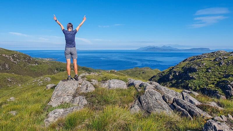
After a magnificent sunrise, almost perfect weather conditions I fell in love with Snowdonia and had a craving to explore more. I went back hiking in the Cadair Idris region, the Carneddau range and Molwyns.
After ticking off the Nuttall’s on my Hiking App, I had an idea that I wanted to hike all the Nuttall’s in Snowdonia (a Nuttall is a mountain over 2,000 ft, as classified by John and Anne Nuttall) but I didn’t consider when I wanted to complete them by.
My Snowdonia 2020 Hiking Challenge
What is my challenge going to be for 2020?
For me, the best way to work out what I want to do is simply research and initial planning. I use Ordnance Survey online to plan the majority of my hikes, so this was no different.
I started plotting a north to south route in Snowdonia, but as soon as I started looking at the best path I naturally gravitated towards the mountains that I knew and loved.
That’s when I combined my idea of a long-distance challenge and bagging all 127 mountains in Snowdonia.
The plan
So, this is the plan…
Start at the furthest southerly point in Snowdonia National Park, a place called Aberdovey. Then walk to the furthest northerly point in Snowdonia.
But the route I will take will tick off all 127 mountains in Snowdonia on the way.
I’ll be unsupported and wild camping for as much of the trip that I can.

How long will it take?
I’ve roughly worked out a route across Snowdonia, it needs some tweaking as much of the route is off the beaten track and I also need to factor in a few stops in towns along the way to refuel and recharge.
After calculating my mileage for the rough route, it totals about 290 miles/470 km.
Based on completing between 9-12 miles/16-20 km per day, I’m thinking that it will take between 30-35 walking days. Then I will need to factor in a few rest days too.
But of course, unlike the E2W Challenge, which had some elevation on the 952-mile route (22,384 metres), this challenge has a few more metres to climb!
I’ve added them up and it seems to be a 30,000-metre challenge. Hmm, maybe I will need to add a few more days to get up to all those mountains.
What will I be taking with me?

On the E2W Challenge, I fitted everything into a 65-litre Osprey backpack for wild camping, sleeping, cooking and a few clothes!
I’ll be carrying all my gear with me for this challenge.
You can read my long-distance packing list here to see what I’m planning on taking.
But there are a few extra items that I will take. On the E2W Challenge, much of the route was via national and local trails so I chose not to take a map with me (I would have needed a ridiculous amount).
For this challenge, I will be hiking in remote parts of Snowdonia so a map and compass will be an essential piece of kit. And a map case, because you know how much it rains in Wales!
When will I be starting the challenge?
The plan, at the moment, is to start the challenge in end of April/beginning of May, but I’m still finalising the details so I will let you know as soon as I decide on a date.
What route will I be taking?
Here’s my very rough idea of the route I will be taking

What order will I be doing the mountains?
With 127 mountains to tackle in one long-distance hike, I needed to be smart about which order I did them in.
Here’s my proposed plan for the mountains I will be hiking up (and down).
I’d love your thoughts on my plan and if you’re an expert in a particular area of Snowdonia please get in touch as I’d love to hear from you and share my detailed plans.
Start point: Aberdovey, south Snowdonia
Mountains 1-12: Cadair Idris range
Mountains 13-26: The Arans
Mountains 27-34: The Berwyns
Mountains 35-36: The Arenigs
Mountains 37-45: The Rhinogs
Mountains 46-55: The Arenigs
Mountains 56-69: The Moelwyns
Mountains 70-80: Moel Hebog range
Mountains 81-92: Snowdon range
Mountains 93-104: The Glyders range
Mountains 105: The Moelwyns (Moel Siabod)
Mountains 106-127: The Carneddau range
Finish point: Penmaen-bach Point, north Snowdonia
Follow my adventures on Instagram
@beckythetraveller
On my hike I will be sharing my challenges via my Instagram Stories (if I have a signal haha) so start following now.
View this post on Instagram
What do you think about the challenge? Would you like to know anything else or maybe you would even like to join me!
Let me know in the comments or drop me a message via Instagram @beckythetraveller
*Becky the Traveller participates in the Amazon Services Associates Programme, as well as other affiliate programmes. If you make a purchase through these, I earn from the qualifying links. This is at no extra cost to you. Read more here.