
Climbing Cadair Idris (also known as Cader Idris) in Wales is one of the best hikes in south Snowdonia/Eryri. The Minffordd Path is one of the best routes with stunning views as you hike past Llyn Cau and then up to the summit.
This Cadair Idris walk takes you on a scenic route up the ninth-highest mountain in Wales, Snowdonia/Eryri National Park, it’s a challenging hike but worth it.
There are three main routes up to Cadair Idris summit at 893 m – the Pony Track, Fox’s Path and the Minffordd Path, although there’s a great scramble option too. (I’ve hiked the Minffordd, Path, Pony Track and scramble route).
The Minffordd Path is the shortest route up to the summit of Cadair Idris. But the shortest also means the steepest route and you’ll feel the elevation increase as you climb higher and higher.

If one mountain summit isn’t enough for your day hike, the route up the Minffordd Path can continue as a circular loop via the second-highest summit of Cadair Idris Mynydd Moel at 863 m.
Here are the full details of my Cadair Idris walk via the Minffordd Path including the circular route back down.
Cadair Idris walk via Minffordd Path

Walk information
Start point: Cadair Idris Car Park
Walk distance: 10 km/ 6 miles
Hiking time: 4-6 hours
Difficulty: Hard
Map: OS Explorer 23 Cadair Idris & Llyn Tegid
Planning your Cadair Idris route
Start by getting yourself the Ordnance Survey OS Explorer 23 map which you’ll need to climb this Welsh mountain. And, of course, a compass too!
Choose your route
I decided on the Minffordd Path for my first hike, mainly because the starting point and car park were a shorter drive from my accommodation in mid-Wales at Hafren Forest Bunkhouse.
But I’ve also walked up via the Pony Track, as well as a fun scramble up one of the gullies near Llyn Cau. (Note – I’ve hiked Cadair Idris in summer and winter conditions – hence the different photos!)
Mountain weather
It’s worth checking the mountain weather forecast before your hike, the weather conditions at the bottom can be very different to Cadair Idris summit.
- Check the weather report for Cadair Idris here (www.mountain-forecast.com)
Start of the hike
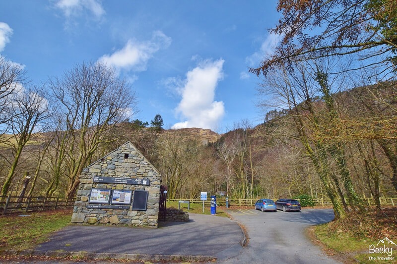
The Minffordd Path walk starts at Cadair Idris Car Park, off the A487, south Snowdonia/Eryri. The closest sat nav postcode is LL36 9AJ but once you turn off the A487, you’ll see the signs for the car park at the base of the Minfforrd Path.
The Minffordd Path car park has a small toilet block with information about Cadair Idris (or Cader Idris) on the outside walls. There are enough spaces for maybe 30-50 cars, the car park can get busy at weekends so it’s worth getting there early.
Minffordd Path car park costs
The sign for Cadair Idris parking costs were £3.00 for up to 4 hours and £6.00 for all day (until midnight), I’d hope you will be back by that time otherwise you might be needing Mountain Rescue.
Card payments only (no cash option) – Updated Oct 2023 (via message from fellow walker)
Want to read later? Save to Pinterest here

Cadair Idris Walk (Minffordd Path Route)
Cadair Idris Car park to Llyn Cau
Hiking distance: 2 km
Hiking time: 1 hour
From the car park, it’s a beautiful and flat start to the walk, down a track towards the tearoom (which was closed in March) then through a little gate.
The flat path lasts about 5 minutes, then the climb starts on the Minfforrd Path and it’s a steep climb so be prepared to get warm. The stone steps take you up through a green wooded area, which is very beautiful, even though tough at the same time.

After about 1 km, the path splits. The right path takes you over a slate bridge signposted Mynydd Moel (this is the end of the circuit on the way back). The left path heads towards Llyn Cau (the lake at the foot of Cadair Idris) via the Minffordd Path.
The path towards Llyn Cau isn’t as steep now so you can catch your breath. As you approach the lake, there’s a huge flat rock, the Minffordd Path route goes up here. From this point on a clear day, you have views of Cadair Idris summit.
Note – Cadair Idris summit is the peak on your right, not the one directly in front which I admit does look higher from this angle!

Top tips for the walk
- If you have a few layers on then I’d recommend taking them off before you start the upwards hike on another steep section of the Minfforrd Path.
- Take a mini side trip to the lake, Llyn Cau for views of Cadair Idris summit. It would make a great picnic stop, you can even go wild swimming
Llyn Cau along Craig Cau ridge
Hiking distance: 2 km
Hiking time: 1 hour

Now you’ve enjoyed the pretty scenery from Llyn Cau, get ready for some more uphill on the Minfforrd Path. Although, on your way up there are a couple of great spots for photos so don’t rush and enjoy the views on Llyn Cau!
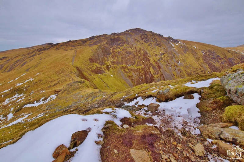
Once at the top of this section, you follow the path all the way along Craig Cau Ridge. This section is particularly challenging, not only is it steep, but there are lots of loose rocks so be careful with your footing.
The path is undulating and takes you on a tough but scenic path, as you can look down to Llyn Cau. Don’t get too close to the edge though, it’s a long way down!
Remember that peak that looked like the summit? Well, you’re about to follow the path around to the right and climb up here. It’s more loose rocks so be careful and there’s a treat at the top, a little stile for you to climb over
Read next – Top day hikes in Snowdonia/Eryri
Craig Cau to Cadair Idris summit
Hiking distance: 0.5 km
Hiking time: 30 minutes
Depending on the weather, the wind can really pick up on this section of the walk.
But if you think the other side will be any different then you’re likely to be wrong. As I climbed over the steps of the stile I was met with a huge gust of mountain wind. Feeling hungry I had planned to stop here for lunch but I quickly decided that was a bad idea.
On a clear day, as you head down this section, you can look across the path up to Cadair Idris. Be sure to keep to the path here as there’s a huge drop on your right and it’s easy to veer off the route!
It was at this point the clouds started to creep across the sky, clinging to the top of the mountain. I opted for a few photos just below the summit. A great view as you look down you can see the path you’ve walked up from the lake.
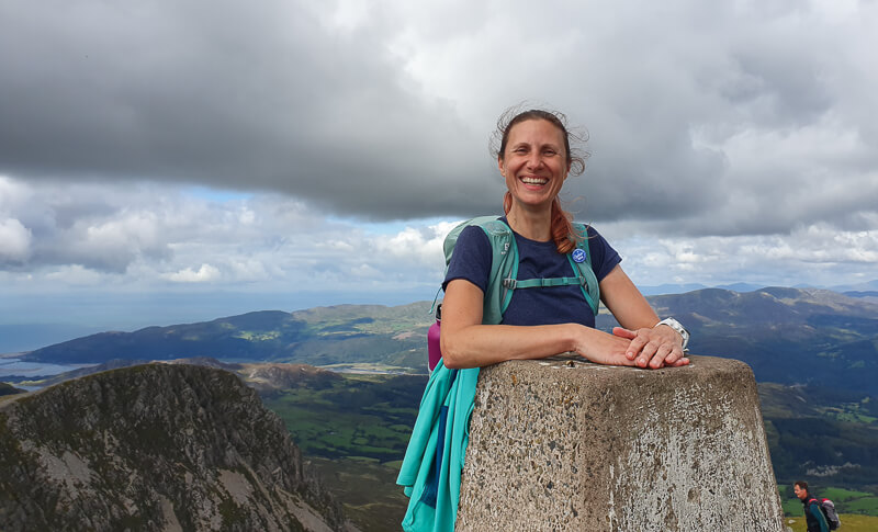
One last climb to the summit of the mighty Cadair Idris. Keep walking uphill then out of nowhere, the trig point appears, yes you’ve made it to the top!
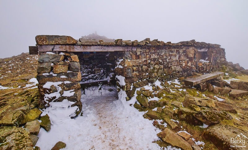
To the left of the summit, there’s a great stone covered shelter. It’s better than the tiny one at the top of Ben Nevis, you could fit maybe 20+ people in there, maybe more. And of course, a perfect place to refuel and have some peppermint tea from my Sigg Hot and Cold flask.
Cadair Idris to Mynydd Moel summit
Hiking distance: 2 km
Hiking time: 30 minutes

From Cadair Idris summit, you have two choices, you can either hike back exactly the same way as you came via the Minfforrd Path.
Or option two is to continue on a circuit and go via Mynydd Moel. The path doesn’t appear on the OS map but it’s a good route all the way down.
This section is a relatively easy hike, the path doesn’t lose too much elevation so within about half an hour you’re at Cadair Idris’s second summit Mynydd Moel. The views from here are lovely and there’s a mini wind shelter at the top as well, handy in windy weather.
Mynydd Moel to Cadair Idris Car Park
Hiking distance: 3.5 km
Hiking time: 1 hour 30 minutes
Now it’s time to start descending back to the finish. The path starts gradually at first but once you reach another step stile it quickly gets steep. The path is full of lots of loose rocks so take your time, now is not the time to fall!
After what feels like forever going downhill, (it makes it worse as you can see the main road in the distance), you reach another step stile on your right.

Climb over this and follow the path all the way down to the slate bridge. (This is where the Minfforrd Path split at the beginning of the walk)
Now it’s back down the steep path to the car park (and it’s so much easier) unless you have dodgy knees like me.
Congratulations you’ve climbed Cadair Idris, the ninth highest mountain in Wales 🙂
Read next 8 BEST walks in the Brecon Beacons
Cadair Idris walk – Clothes, Gear + Tips for the Hike

What to wear for hiking Cadair Idris?
My recommendations for what to wear when hiking mountains are always the same.
Whether it’s Ben Nevis in the UK or Mt Kilimanjaro in Tanzania, the key is layers. As you climb a mountain the weather changes the higher you go up, more wind and it’s definitely cooler at the top.
Did you know it’s about 9 degrees difference between the top and bottom of Ben Nevis in Scotland?
Bear in mind that walking up Cadair Idris via the Minfforrd Path, it’s steep, especially the first section so it’s best not to have too many layers for the uphill hike. But you will want them at the mountain summit!
Another essential item is good hiking boots. They offer support for your ankles, especially on those rocky sections.
More UK hikes – 22 day hikes in the UK
Top tips for climbing Cadair Idris (via the Minffordd Path route)

- Be prepared for how steep this walk is, especially the downhill sections too – hiking poles offer extra support
- Stop by the lake (Llyn Cau) for photos, it’s slightly off the Minffordd Path route
- Pack extra warm layers and waterproofs (even if it’s not supposed to rain)
- Take a map and compass on your walk, if the cloud comes in then you can’t rely on just looking for the path
- If you’re hiking solo tell someone you are doing the hike (and to let them know you’re back safe)
- Pack some lunch and a hot drink
- Remember your First Aid Kit with a few essential items
Planning your Cadair Idris walk in Snowdonia/Eryri? Ask me any questions about the Minffordd Path (or other routes) in the comments
Love hiking? Read more of my hiking adventures here
*Becky the Traveller participates in the Amazon Services Associates Programme, as well as other affiliate programmes. If you make a purchase through these, I earn from the qualifying links. This is at no extra cost to you. Read more here.
I climbed this route in August 2005 or 2006 with my mum, dad & brother. There was no bridge then but we didn’t realise until we got to the river, we had to cross it.
haha oh blimey, I had no idea the bridge was that new! Maybe it’s time for you to hike it again and experience the new bridge hehe 🙂
I’m thinking about doing the Minfford Path hike in a few weeks time, so thanks for the Tips, Becky!
Ah brilliant Jan, it’s a beautiful walk, hope you enjoy 🙂
thinking about doing this hike in early december! is this recommended? i read from a couple websites that it’s too dangerous to hike after october
Hi Mel, great question, it is difficult to answer because the main reason it could potentially be dangerous is the weather. Windy and cold conditions can be dangerous if you don’t have the right equipment and also strong winds can blow you off your feet. The second weather that I assume most people are referring to would be snow and ice, in that case you’d need winter boots, crampons, ice axe and proper warm clothes. If you’ve not used this equipment or don’t own then it could certainly be very dangerous to hike. Early December can be mixed weather so I’d recommend that you’d need to see what the weather is like at the time you’re planning to do the hike. Check Mountain Forecast weather, Met Office, MWIS (Mountain Weather Information Services) to see accurate forecasts to make your decision. Hope that helps with your decision making. Becky
Hello Becky, me and my sisters are thinking about doing the hike, but only to Llyn caw, because this is our first hike ever. I was wondering if it was doable in january, and if it was difficult for beginners (we are used to walk for 14 km per day, but in cities), or if it is too steep. Thank you
Hi, no I’m sure that would be fine, but you may need microspikes if it’s icy this time of year. The steepest section is right at the beginning through the woods then it’s more gradual and if in doubt, you can always turn back 🙂
Looks like a lovely route. Is this route safe to do with a dog?
Hi Emma, I’m sorry, I couldn’t say for sure as I didn’t do with a dog. I do have a vivid memory of a lady struggling to get her dog over the step stiles and in addition, there are some steep dogs so I’d say you’d need to keep them on a lead for safety. Hope that helps 🙂
Hi Becky,
Just a correction about car parking payments which are now card only (no cash payments accepted). The charges are still the same however.
Ah fab, thanks Mark, I’ll update that information. Hope you had a great hike 🙂